
ROUTING: The 2014-15 Volvo Ocean Race
Published on April 29th, 2013
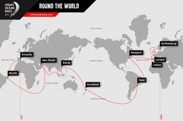
Volvo Ocean Race meteorologist and all-round route expert Gonzalo Infante details the nine legs of the 2014-15 route, detailing the 39,895 nautical miles which will take nearly nine months to sail.
Leg 1: October 11, 2014 – Alicante, Spain to Recife, Brazil – 3,421 nm
It will be a familiar start for the Volvo Ocean Race fleet as they head out of the Mediterranean into the Atlantic. The difference this time is that the leg finishes in Recife in the north east of Brazil.
It all begins with some unpredictable coastal sailing in the Mediterranean Sea. The autumn weather in the Levante area, from Valencia to Murcia, is an extreme season. Why? Because the air is cold and the Mediterranean Sea is still warm, which enhances the chances of low formations. These are very favourable conditions for storm development. They create a lot of short and choppy waves too, which are very hard on the boats and the sailors.
The Alboran Sea, from Palos to Gibraltar, is the perfect wind channel with high mountains on the Spanish and the Moroccan sides. On top of this is a permanent oceanographic feature with a lot of current due to the exchanges between the Atlantic Ocean and the Mediterranean Sea. From Alicante to Palos, the big gains or losses are about playing the coastal effects. A lot of strategy will be involved and will depend on the direction of the wind too – in autumn, it usually blows from the east but in case of westerly winds it will be an upwind Mediterranean exit.

Crossing Gibraltar is always very tricky. The weather at this transition point is either very rough or very light. If rough, it’s difficult because of the traffic and the sea state. If light, you can go backwards!
Before crossing, you also have to decide on your strategy after Gibraltar – going west at the beginning or going south-southwest to follow the traditional trade winds. That decision depends of how well established the trade winds are. Last time there were just a bit late and west was best: Groupama missed them when following the African coast.
Then comes the doldrums crossing. This time, as the race starts sooner, Doldrums can be a little bit more painful to cross, since the area of squalls is at the same latitude as the equatorial calms, with little wind to escape from these big cells. As usual, the doldrums are narrower on the west and the area gets wider as you get closer to Africa.
Once the doldrums crossed, you enter the southeasterly trades. The more eastern you cross though, the more you will be able to open the sheets afterwards in these trades. It will be close to the beginning of the Austral summer, as the fleet will sail at reaching angles to Recife.
Leg 2: November 9, 2014 – Recife, Brazil to Abu Dhabi, UAE – 9,707 nm
The longest and most diverse leg of this 12th edition, it will go from the hot Tropics to the freezing Southern Ocean and back to the heat again in Abu Dhabi.
You have two options to start with: rounding the St. Helena High to catch the Southern Ocean westerlies or cutting its corner. When you round it, the South America lows push you very quickly towards the Roaring Forties. In any case, the goal is to catch these westerlies as soon as possible before heading east fast. Obviously that course will depend a lot from the ice limits.
The next challenge is to pick the right moment to head north again. The transition from the Westerlies in the Southern Indian Ocean to the northern trades of the South Pacific High is a tricky one. It’s difficult to go from westerly to easterly winds! If you get too close from the high, you may get stuck. But if you stay too far, you will end up doing a lot of upwind sailing.
Then comes another Doldrums crossing. These ones are bigger and more unknown than the Atlantic doldrums. The Indian Ocean is very different from the Atlantic one… This crossing can change whatever has been done until this point. Like Groupama last time, you can lose it all by being at the wrong place at the wrong time – the story of life!
After the Doldrums you have to sail upwind from Cape Comorin up to 500 miles off Hormuz in the monsoon winds. Once closer to the Gulf of Oman, you enter in some kind of no man’s land between the Arabian Sea and the Gulf, where the wind is very unstable. With the Shamal wind’s help, you can finally blast towards Abu Dhabi.
Leg 3: January 3, 2015 – Abu Dhabi, UAE to Sanya, China – 4,670 nm
The highlights of this leg are evocative of some very exotic eastern travel – leaving the Emirates for India, Malacca and Singapore, choosing between Borneo or Vietnam and finally the Hainan island in China.
The start is the inverse of the previous leg: reaching towards Hormuz before entering a transition area and sailing downwind in the monsoon. Once you cut the corner of Cape Comorin, the northeasterly trades are still there but they are weaker. The monsoon winds shift at the Equator. You have to decide if you prefer to go a little bit more south and get a better angle. But all in all it usually is a bit light for such gains to make the difference.
Usually, as you get closer to Malacca, the wind shifts to north northeasterly and you have to decide where to tack. You don’t want to dive too far south on the Sumatra lee side neither. It’s a very tactical approach.
Malacca is a very random place with a generally light wind. The Equator is not far and there are a lot of navigation hazards. The seabed is not fixed and the navigation charts are not very good in the area. Lots of traffic, lots of land breeze too: every day in Malacca is different! The fact that you sailed there before can actually play against you. The key question is whether to use your experience or be open-minded. I would go for the second option.
Then it’s the Singapore Channel, a very narrow one. There isn’t much room out of the traffic lanes and it’s not good to upset merchant vessels. The first miles in the South China Sea are normally upwind but might also be sailed downwind. Stick to the Malaysia coast instead of the Vietnamese to enjoy the Borneo Vortex breeze if there is any and you might be rewarded. The final beat towards Sanya will most probably be a rough upwind one.
Leg 4: February 8, 2015 – Sanya, China to Auckland, NZL – 5,264 nm
This north-south leg can take you much further north than expected to start with! It will also have the flavour of a homecoming for all the Kiwi sailors involved in the race.
Let’s pray for the South China Sea conditions to be better than last time. This time around the One Design boats will be able to take on tougher conditions, but the crew will get seasick anyway. Anyone willing to try the new class should not pick that leg!
The Luzon Strait can be very windy. The course to take will depend on the strength of the trade winds. If they are well established in Luzon, you can head directly to the Solomon Islands in the south east. If they are not, you will have to go to the east, even sometimes to the north. Last time PUMA and Groupama went pretty close to Japan – that was one extreme option! It’s the proof that in offshore racing, the quickest way isn’t always the most logical or the shortest one.
Another doldrums crossing around the Solomon Islands and an interesting passage through the archipelago before to find the trade winds once again. Only this time they are affected by the Tasman Sea. There is some tropical activity in this area: any small doldrums storm can develop into a tropical storm when drifting south. One of these could very well get between the fleet and the leg finish in Auckland.
West or east, two different approaches of the New Zealand northern tip are possible depending on how steady the systems are. Finally it’s some coastal sailing to the City of Sails.
Leg 5: March 15, 2015 – Auckland, NZL to Itajaí, Brazil – 6,776 nm
Strong winds, deep waves, freezing temperatures and albatrosses – this leg is made of all the Southern Ocean clichés! To make it across the Roaring Forties in one piece before rounding Cape Horn and sailing along the South American coast is an achievement in itself.
The start from Auckland can be dangerous if a tropical system drifts south and gets into a powerful low pressure with strong north winds.
One of the leg’s most dangerous situations is the presence of ice and you have got to stay north of the 40° S. But by staying north of that latitude, a tropical system is very likely to be on your route and you’ll have to sail in strong easterlies – that would be the worst scenario.
The low pressures travel so fast in the South Pacific that they have a big impact on the sea state. The swell has no fixed direction and it’s difficult to direct your boat to preserve it. Temperatures are freezing down there and relative humidity is close to 100%. Everything is full of water!
Another big thing is obviously the approach to Cape Horn. There are around 500 miles between the Cape and the northern tip of Antarctica – it’s going to be full of action. Worst case is the northwesterly wind because the Andes physical situation increases its strength by more than 100%.
After the Horn comes the return to civilisation, which means returning to an aggressive strategy at short and medium range. Most frequently you want to stay as much time as possible into the westerlies by staying close to the Argentinean coast, before getting into the variable weather related to the South Atlantic High.
Getting closer to Brazil and Florianopolis, thunderstorms appear and threaten the fleet until the arrival in Itajaí.
Leg 6: April 19, 2015 – Itajaí, Brazil to Newport, USA – 5,010 nm
This is a coastal leg with some good offshore options to consider. Whatever happens, looking good as the Race arrives in the great sailing city of Newport for the first time ever will be very important to most of the sailors.
After leaving Itajaí the weather is very stormy and variable. There are warm currents close to the coast. Offshore or inshore? Sea breeze or land breeze? Land breeze is a good night feature in Brazil but it’s not constant.
Then you should catch the south easterly trade. Once in them there is all about performance before another Doldrums passage with trade winds again to follow.
Don’t travel too far east in the northern hemisphere or you’ll end up doing a lot of upwind sailing.
From Miami’s latitude to Newport, you have to choose between playing the Gulf Stream and staying offshore to play the weather systems until Rhode Island.
Leg 7: May 17, 2015 – Newport, USA to Lisbon, Portugal – 2,800 nm
The transatlantic leg is a highly symbolic one. The sailing can be rough and emotions are high as the fleet goes back to Europe, home of the race.
It’s a spring crossing, the fastest feasible time to sail across the Atlantic. The winter in the North Atlantic is a bit of a drama. Spring is more feasible but you have got to be careful when trying to find a good way below the northern storm track.
So you’re in for a bit of rough weather sailing, riding low pressures to go fast. At some point you have to dive south to head towards Portugal. That’s another tricky connection to the Portuguese trades. They take you all the way to the Portuguese coast before a gorgeous leg finish in the Tagus River.
Leg 8: June 7, 2015 – Lisbon, Portugal to Lorient, France – 647 nm
The first European leg takes you through the Bay of Biscay, which is always a sailing milestone. In the last edition, the boats went through one of their worst storms just before arriving in France so do not underestimate these 647 nautical miles.
In 2015 the fleet will go straight and not around the Azores as we did in 2011-12. Is it going to be a very fast one then? Not for the first miles, as they will have to beat upwind.
The Spanish coast can steer things a bit with some thermal effects on the northwesterly winds.
Then the Bay of Biscay is always interesting. It can be very windy if a good storm is coming from the North Atlantic; it can be very light if a low pressure just went across the Bay.
Leg 9: Start date to be decided – Lorient, France to Gothenburg, Sweden – 1,600 nm
This might well be my favourite leg. Though it could also be the hardest one of the whole race! It’s so short it will be high intensity. There will be a lot of coastal sailing, navigational hazards, strong currents and potential rough weather. Don’t forget the crews will be really tired after eight months of sailing too. Definitely a fascinating one!
First you have got to round the British Isles. Summer time or not, the weather is likely to be bad and the sea state nasty. There is no escape: you cannot get away from the coast or you will sail too many miles.
There are very strong currents around the Shetland Islands and it may very well be an awful passage.
The North Sea is full of oil rigs and wind farms. Again the weather can be very, very rough or very, very light.
Then comes the Gulf of Finland and the approach to Gothenburg, on the western coast of Sweden, for the finish of the Volvo Ocean Race 2014-15.

Related Posts
Pirates in the Indian Ocean →
The Ocean Race Europe begins in Kiel →
Challenges, triumphs, and team spirit →
 We’ll keep your information safe.