
First storm of Atlantic Hurricane season
Published on May 9th, 2015
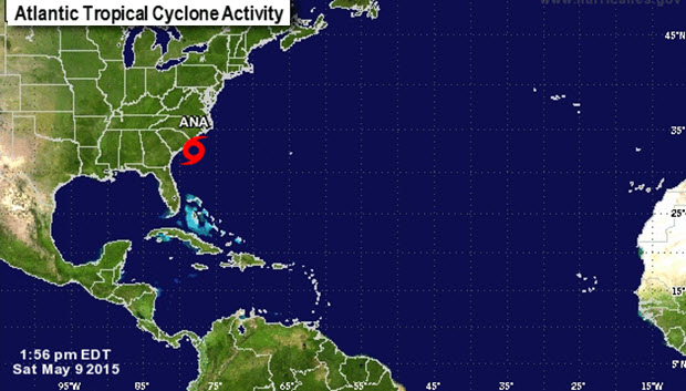
The first storm of the Atlantic Hurricane season formed nearly a month before the official start date of June 1. Here’s an update for Tropical Storm Ana from the National Hurricane Center as of 2:00 PM EDT SAT MAY 9, 2015…
LOCATION…32.7N 78.1W
ABOUT 85 MI…135 KM SE OF MYRTLE BEACH SOUTH CAROLINA
MAXIMUM SUSTAINED WINDS…60 MPH…95 KM/H
PRESENT MOVEMENT…NW OR 320 DEGREES AT 3 MPH…6 KM/H
MINIMUM CENTRAL PRESSURE…1001 MB…29.56 INCHES
WATCHES AND WARNINGS
——————–
CHANGES WITH THIS ADVISORY:
None.

SUMMARY OF WATCHES AND WARNINGS IN EFFECT:
A Tropical Storm Warning is in effect for…
* South Santee River South Carolina to Cape Lookout
A Tropical Storm Watch is in effect for…
* Edisto Beach South Carolina to South of South Santee River
A Tropical Storm Warning means that tropical storm conditions are expected somewhere within the warning area, in this case within 12-24 hours.
A Tropical Storm Watch means that tropical storm conditions are possible within the watch area, in this case within 12-24 hours.
Interests elsewhere in eastern North Carolina and Virginia should monitor the progress of Ana.
For storm information specific to your area, including possible inland watches and warnings, please monitor products issued by your local National Weather Service forecast office.
DISCUSSION AND 48-HOUR OUTLOOK
——————————
At 200 PM EDT (1800 UTC), the center of Tropical Storm Ana was located near latitude 32.7 North, longitude 78.1 West. Ana is moving toward the northwest near 3 mph (6 km/h). A turn toward the north and north-northeast with a gradual increase in forward speed is expected over the next 48 hours. On the forecast track, the center will be very near the coasts of South and North Carolina by Sunday morning.
Maximum sustained winds are near 60 mph (95 km/h) with higher gusts. Gradual weakening is forecast as Ana moves over cooler waters close to the coastline overnight. A more rapid rate of weakening will begin after the center crosses the coast.
Tropical storm force winds extend outward up to 125 miles (205 km) from the center.
The estimated minimum central pressure is 1001 mb (29.56 inches).
HAZARDS AFFECTING LAND
———————-
WIND: Tropical storm conditions are expected within the warning area, and are possible within the watch area, by later this afternoon or this evening.
STORM SURGE: The combination of storm surge and the tide will cause normally dry areas near the coast to be flooded by rising waters. The water could reach 1 to 2 ft above ground at times of high tide in coastal areas from Cape Hatteras, North Carolina southward through South Carolina. For information specific to your area, please see products issued by your local National Weather Service forecast office.
RAINFALL: Ana is expected to produce rainfall accumulations of 1 to 3 inches, with isolated amounts of 5 inches, over eastern portions of North Carolina and South Carolina through Monday.
SURF: Swells generated by Ana are affecting portions of the southeastern U.S. coast. These swells will likely cause life-threatening surf and rip currents. Please see statements issued by your local National Weather Service forecast office.
Source: http://www.nhc.noaa.gov/text/refresh/MIATCPAT1+shtml/090232.shtml

Related Posts
Is your name on the 2024 storm list? →

Are alarm bells beginning to go off? →
‘Extremely active’ 2024 hurricane season →

 We’ll keep your information safe.