
Volvo Ocean Race: Clown Fish and Rocket Debris
Published on January 1st, 2018
Anderson Reggio is providing shoreside navigation support for Team Vestas 11th Hour Racing in the 2017-18 Volvo Ocean Race. When the fleet starts its next leg on January 2, Reggio had to analyze a course that had yet to be traveled in the 12 prior editions of the race. Here’s what he learned:

Anderson Reggio
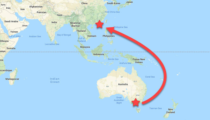
After a short break and a hectic round of repairs, the Volvo Ocean Race fleet is gearing up to take on one of the most complicated legs of the race, leg number four from Melbourne, Australia to Hong Kong. Climatologically, navigationally, and psychologically, leg four is incredibly challenging and really hammers home the sense of how truly relentless this race can be. And to think, it is only 30% done.
Melbourne sits at the northern end of Port Phillip Bay and the starting line adjacent to the city means the teams will have forty miles of upwind, VMG sailing in a building breeze straight out of the gates. A true test for any squad will be made more challenging when the exit from the bay includes a 12 mile stretch down the South Channel before leaving through a narrow passage known as The Rip.
Five to seven knots of outgoing tide against an anticipated strong southwesterly breeze can make for an absolutely heinous sea state with standing waves that could be multiple meters high. There won’t be much of a chance to simply ease into this leg.

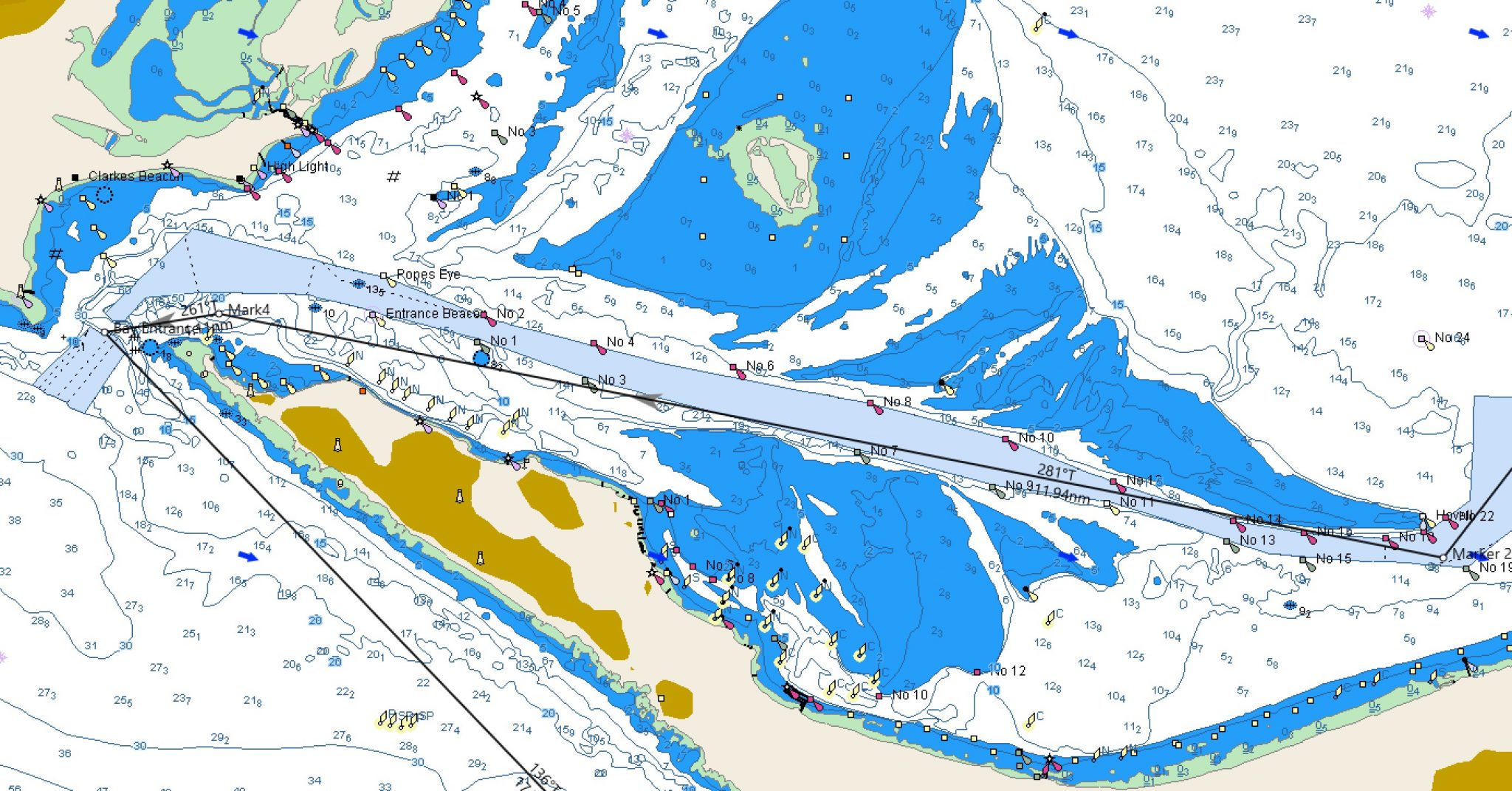
The South Channel and exit through The Rip. Teams encounter this before reaching open ocean only after sailing upwind for 30 miles. (image from Expedition)
Out of the bay, tensions should ease some as things get a bit more straightforward as teams work down the coast towards Wilson’s Promontory. A TSS (Traffic Separation Scheme) sits there which they must honor to port before heading out through the Bass Strait and into the Tasman Sea. The SW wind should hold for the fleet throughout this time, giving them a fun, fast 100nm reach before freeing up as they turn left towards Cape Howe after rounding the Wilson TSS.
The high settled in under the Australian Bight will be the main driver for the wind throughout this period and the first VMG run of the leg to Cape Howe should be eaten up fairly quickly. Options abound for how to play this difficult stretch and we will likely see a few different strategies play out.
From there the complexities have only just begun. The Eastern Australia Current which runs down the coastline is famous for massive speeds and random eddies. Three knots or more of current against is strong enough for even the fastest of boats to want to pay attention. Throw in a gyre or two where this can be used in your favor and everyone will be playing the game of watching sea temp to see where these gyres really lie.
Want some more background? Everything you need to know about this current can be found here. Watch out for clown fish taking the exit for Sydney.
So we’re out through the strait and up past the current and finally the boats will transition into nice SE trade wind sailing, taking them 1700 miles towards the next turning mark at Santa Ana Island to the east of Papua New Guinea. All sounds simple until you zoom in close on Google Earth and realize there are two meter high islands scattered all over the rhumb line.
Atolls galore dot this stretch of what should be open ocean, giving the navigators headaches even when the sun is up. Tactically teams will be playing a game of cat and mouse with one another relative to these spatterings of land as they set up for a transition out of the trades and into the doldrums.
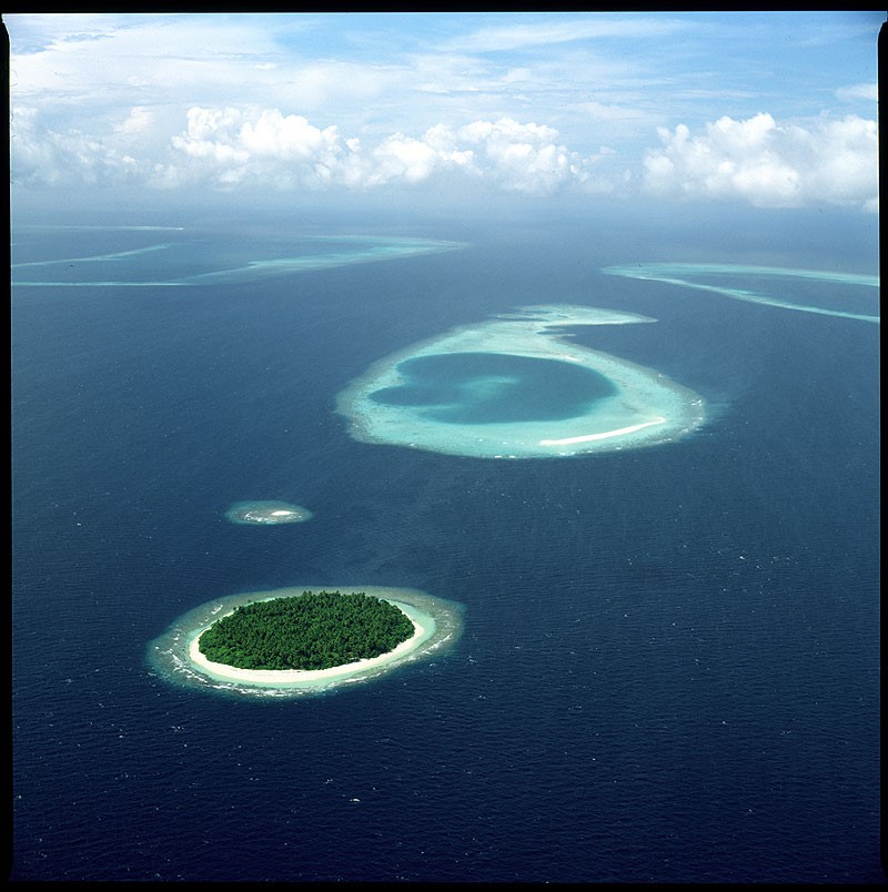
Atolls and small islands dot the Coral Sea
For those paying close attention to the race, you will recall the doldrums of leg two were not as fierce as they have been in the past; the fleet got through with relative ease. Again, our good friend the doldrums returns to greet us in leg four as the southeast trades of the southern hemisphere must transition somehow to the northeast trades that dominate the northern Pacific.
Tactically there are many ways to get through this area and the struggle will be to weigh progress towards the goal post of Hong Kong to the northwest against potentially getting into the trades faster by pointing north.
Going for Hong Kong directly may mean that you miss out on getting into the trades earlier than your competition even though you might look glamour on the leader board. This will weigh heavily on the fleet as they bake under the equatorial sun in little to no wind for what could be 250 – 300nm.
Once they’re into the northeast trades, it is back to fast and fun atoll dodging through Micronesia and the Mariana Islands, rocketing towards the Philippines.
Speaking of rockets, a notice to mariners just came out for a broad area of the western Pacific sighting a potential for rocket debris to fall to earth following a JAXA (Japan Aerospace Exploration Agency) launch early January. Literally the sky may be falling on the fleet as they sail by. As if they didn’t have enough to worry about…
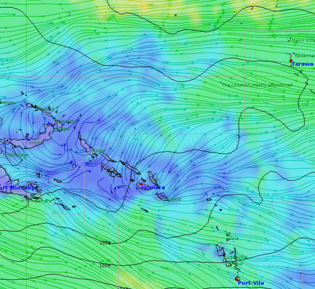
Southeast trades transition to northeast trades via a large light area in the vicinity of the Solomon Islands. (image from Squid)
The final major hurdle to the leg is the South China Sea. The seasonal northeast monsoon is in full swing and can easily reach 40kts as it accelerates around Taiwan both between it and mainland China and also through the Luzon Strait. A strong Siberian High compresses the pressure gradient and the breeze just simply pumps and pumps.
Boat breaking conditions were experienced in this stretch of water each of the last three editions of the race. Luckily this time the fleet will be approaching with a bit of a more manageable angle both in and out given the destination of Hong Kong, but that also changes the game significantly in terms of how to play it.
The whole strategy through this stretch may well come down to who manages the Taiwan shadow and associated shifts the best. Crucial miles can be gained or lost quite easily and, with just a few miles to go from here to Hong Kong, there won’t be many opportunities left.
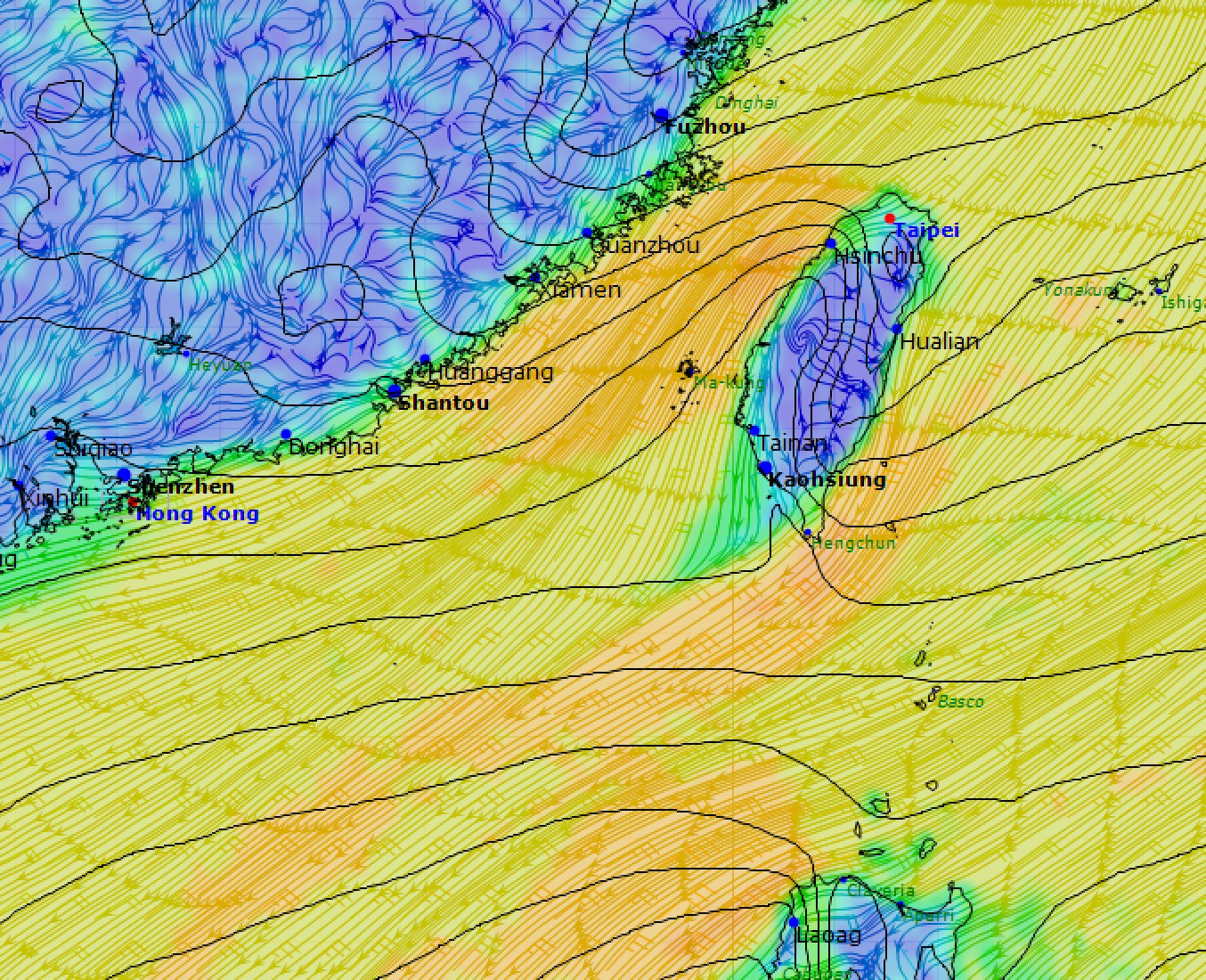
The wind accelerates aggressively around Taiwan whose shadow can often extend for over a hundred miles downwind. Note the aggressive shifts in the wake of the island and through the Luzon Strait. (image from Squid)
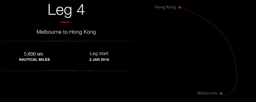
Sticking to tradition, it wouldn’t be the Volvo Ocean Race without a complicated finish. Variable winds, TSS zones, shipping, fishing, and strong current will make for a challenging final 9 miles into the finish in the middle of Hong Kong. Every inch of a lead will be tested along this final stretch as winning the grueling 5600nm leg could all hinge on who manages this stretch the best.
On approach teams will be pouring over the playbook for what can happen given the conditions and all are well advised to be ready to throw it out the window and sail by the seat of their pants as this place can make for some very complicated sailing.
To see Leg 4 crew lists… click here.
Race details – Tracker – Scoreboard – Race route – Facebook – YouTube
2017-18 Edition: Entered Teams – Skippers
• Team AkzoNobel (NED), Simeon Tienpont (NED)
• Dongfeng Race Team (CHN), Charles Caudrelier (FRA)
• MAPFRE (ESP), Xabi Fernández (ESP)
• Vestas 11th Hour Racing (DEN/USA), Charlie Enright (USA)
• Team Sun Hung Kai/Scallywag (HKG), David Witt (AUS)
• Turn the Tide on Plastic (POR), Dee Caffari (GBR)
• Team Brunel (NED), Bouwe Bekking (NED)
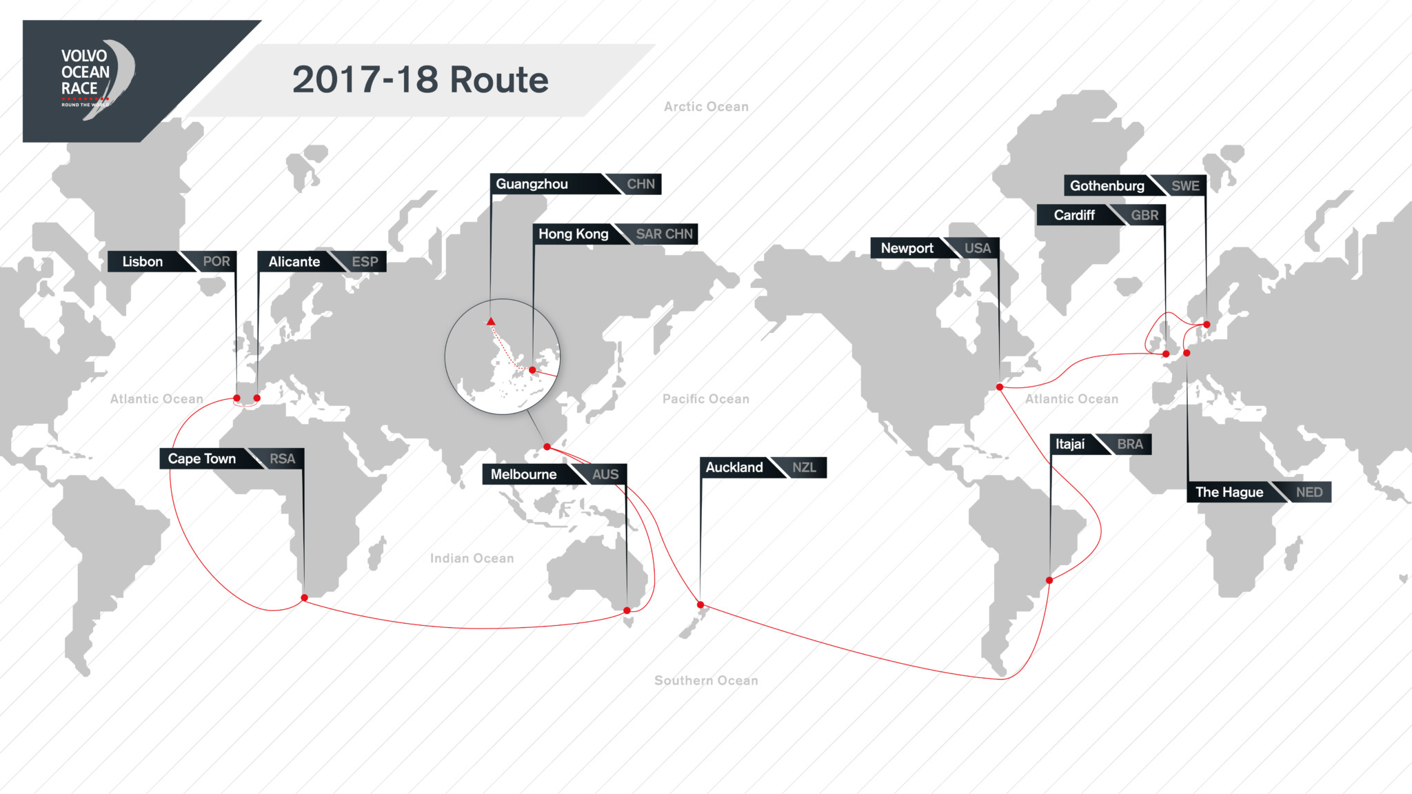
Background: Racing the one design Volvo Ocean 65, the 2017-18 Volvo Ocean Race begins in Alicante, Spain on October 22 2017 with the final finish in The Hague, Netherlands on June 30 2018. In total, the 11-leg race will visit 12 cities in six continents: Alicante, Lisbon, Cape Town, Melbourne, Hong Kong, Guangzhou, Auckland, Itajaí, Newport, Cardiff, Gothenburg, and The Hague. A maximum of eight teams will compete.
Source: Volvo Ocean Race

Related Posts
Pirates in the Indian Ocean →
The Ocean Race Europe begins in Kiel →
Challenges, triumphs, and team spirit →
 We’ll keep your information safe.