Displaying the Waves of the World
Published on January 13th, 2017
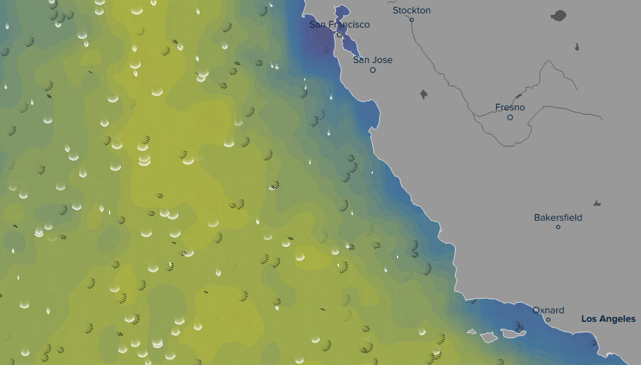
Ventusky, a web application which displays weather from around the world, has introduced a unique wave visualisation system to its online tool. With the help of animated arcs, it shows the movement of waves in the oceans and seas across the world.
The map clearly depicts how waves propagate across the water’s surface in relation to the wind. The visualisation also exposes hazards that arise in specific areas (places where the wind blows in a direction opposite of the direction of the waves, for instance).
The animated lines in the application also depict wind visualisations, which are much easier to create than wave visualisations. Creating wave visualisations is much more complex due to the manner in which waves propagate in the ocean.
The reason is that the wind does not affect the height of the waves solely in that specific location, but also in locations hundreds of kilometres away, which may be completely windless. As a result, the visualisation takes into account not only the direction of wave propagation, but also their height.

The application displays two types of waves: swells and wind waves. Waves travelling outside of their place of origin, and are thus not caused by local winds, are called swells. Waves caused by winds in that specific location are called wind waves. The total height of the wave is the combination of the height of the swells and the height of the wind wave.
In the application, wind waves are marked in white and swells are marked in black.
This feature allows you to quickly find areas where high wind waves are travelling in a different direction from the swells. This situation is very dangerous for boat transport (waves are much less predictable and it is very difficult for sailors to control their boats in such situations). Another highly dangerous situation arises when the wind is blowing against the direction of the waves, making them much steeper. The application can also display the period of the swells and wind waves.
Data for this application is supplied by the highly precise German ICON model, with a resolution of approximately 13 km. The data from this model is used primarily for directing maritime transport, which requires superior predictions. The Ventusky application is the first to make data from this model accessible to the general public.
The goal of the application is to offer highly precise data on waves in the oceans and seas not only to sailors, but also to surfers and swimmers, and thus increase overall safety. It is the first on-line application that displays ocean waves to such a comprehensive degree.
View wave display: https://www.ventusky.com/?l=wave
About InMeteo
The VentuSky web application is operated by the Czech company, InMeteo, which works in the analysis and visualisation of meteorological data. It has been providing the general public with meteorological information for over 5 years. InMeteo boasts long-term collaborations with international companies. It has been operating one of the most popular Czech servers, In-počasí, for several years, which helps provide the general public with weather information. It allows anyone to participate in providing weather information, whether through semi-professional meteorological weather stations or by sending short weather news. It has created a one-of-a-kind service on the Czech web that connects people and improves overall awareness about meteorological events in the atmosphere.
Source: David Prantl

Related Posts

Will e-sailing be a bridge too far? →
Boats will soon be sailing themselves →
Wingsail rigs: Dual, inflatable, retractable →
 We’ll keep your information safe.