Changes in Offshore Navigation
Published on June 19th, 2015
Here’s a challenge: Sail 635 miles mostly out of sight of land. Cross a chaotic current and then make your landfall on a low island behind a reef. (Oh. . . and you’re navigating a race.)
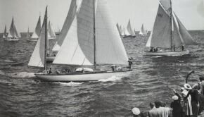
A typical navigator during the first 70 years of the Newport Bermuda Race was described humorously by a shipmate as “crawling from the main hatch like a strange, subterranean animal. With eyes red and bleary from peeking through a sextant all the afternoon, he examined the sky critically and then dove below for his instruments.”
Back on deck, the typical navigator handed a stopwatch to the timekeeper, took sextant sights of the sun or a star, and slid back below to calculate the fix using thick printed tables and a special clock called the chronometer. And so it went, three or more times a day.
The routine was too demanding for most sailors, but others loved it. George W. Mixter was the cook in a boat in the 1926 Bermuda Race when he “caught the germ.” By 1940 he knew enough to publish his authoritative manual, Primer of Navigation.

“Before Loran came in, the navigator was like a priest,” says Larry Glenn, who navigated his Runaway and other boats to Bermuda many times. “People were always asking, ‘Where are we?’, and when you blindly put your finger on the chart, they’d believe you and say, ‘Ahhh,’ in a respectful way.”
The moment of truth concerns the location of the island chain that another navigator, Nick Nicholson, calls “that little speck of land in the middle of the ocean.” He wrote in Practical Sailor, “All the self-doubts about what you had done for the last three or four days piled up at once. Were my sights accurate? Do I really have a clue? The first time Bermuda popped up in front of the boat approximately when and where it was supposed to be, it was a divine revelation. There was meaning to the universe.”
Some boats missed the island altogether. “The rumors of beam and quarter landfalls were as many as the denials were vociferous,” wrote the race’s first historian, Alfred F. Loomis. This doesn’t mean that navigators always know the boat’s exact position. Says Larry Glenn: “Someone would ask you, ‘Where are we?’ and you’d have to say, ‘I don’t know,’ and then he’d say, ‘Well, I’m going to sleep with my feet forward in case we run into the reef.’”
The reef has stopped only one boat in Bermuda Race history. That’s because navigators are clever, skilled, and (we must add) lucky folk. Some of them gauge how far they are off the rocks by inspecting the height of the waves. At least one navigator has trailed a cruise ship to the island. A few even claim they followed the scent of oleander and other flowers wafting from Bermuda’s pretty gardens.
Navigation Goes Tactical
After a big scare in a storm in 1972, when several boats hove-to rather than risk piling up on the reef, the race permitted crews to use Loran-C and Omega electronic navigation instruments within 50 miles of the start and finish. By 1980 electronics were allowed throughout the race and old habits were changing. When Loran and, later, GPS were proved to be precise, many navigators were tempted to throw out old disciplines, like keeping a dead-reckoning plot on a chart based on the boat’s course and speed.
One of the true believers in the DR was Jim Mertz, who navigated 17 Bermuda Races and sailed a record 30. “Once, we had a Loran expert on board and didn’t keep up the DR,” Mertz said. “When we got near Bermuda the Loran coverage ended. I learned two things from this experience. Number one, keep up the DR. Number two, don’t let the navigator stand watch. It takes a lot of energy to keep up a DR.”
Navigation became tactical in the 1980s with Gulf Stream analysis by Jennifer Clark and other oceanographers. Until then, navigators focused on compensating for the Stream’s easterly set. When Carleton Mitchell and his yawl Finisterre won three Bermuda races after entering the Stream 12 to 15 miles west of the rhumb line, navigators laid their courses for “Mitch’s Buoy.” The new electronics encouraged more flexibility.
In 1982 Carina was aimed almost at Bermuda when Richard Nye poked his head up through the companionway and took a look around. Way up to windward, a lightning bolt flashed down to the water. “Tack,” Nye ordered. The crew looked at him incredulously. Someone told him they were only 10 degrees off the layline to the island. “Tack! There’s lightning to windward! There’s warm water up there! The Stream’s up there!” Carina sailed on the “wrong” board until she was in hot water, tacked back, and charged toward St. David’s Light making 10 knots over the bottom. She won her division and almost won the race.
Tactical navigation is in full maturity. To quote oceanographer and Bermuda Race navigator Frank Bohlen (writing in the 2012 Bermuda Race program): “For the Newport Bermuda racer, the point at which the Gulf Stream is encountered is often considered a juncture as important as the start or finish of the race itself. The location, structure, and variability of this major ocean current and its effects all present a particular challenge for every navigator and tactician.”
The crucial importance of navigation, in all its forms, is reflected in eight of the Bermuda Race’s trophies. The George W. Mixter Trophy is presented to the navigators of the corrected time winners in the Gibbs Hill and St. David’s Lighthouse divisions, and the Navigator’s Prize goes to the winning navigator in the Cruiser Division. The Schooner Mistress Trophy is awarded to the navigator of the first Lighthouse Division boat to finish. The Dan A. Kimball Trophy is presented to the navigator of the top Naval Academy boat in a ceremony at Annapolis.
The race’s long sextant history is honored by three trophies with sextants: the William L. Glenn Family ParticipationPrize, the Chesapeake Bay Memorial Trophy for the top finisher hailing from the Chesapeake region, and the Ray Graham Bigelow Memorial Trophy for a class winner in St. David’s.
You’ll find a lot of helpful information about the Gulf Stream, weather, past races, and tactical navigation (including Frank Bohlen’s article and a video of the Navigator’s Forum following the 2014 race) on this website at Gulf Stream & Weather and Race Commentary.

Source: Newport Bermuda Race

Related Posts

Breaking eggs to make an omelet →
Redress for Newport Bermuda Race →
Line honors for Newport Bermuda Race →