Avoiding high-risk areas for participants
Published on October 3rd, 2022
The inaugural Global Solo Challenge 2023-24 seeks to be a budget-friendly solo, non-stop race around the world. For boats from 32 to 55 feet with an IRC rating below 1.370, over 50 entrants will have a pursuit start across 11 weeks in A Coruña, Spain which will deem the first boat to return the winner.
The route gets explained in this report:
When we talk about single-handed round-the-world races by the three great capes sailing towards the East, like the Global Solo Challenge (GSC), we tend to think of the total freedom participants will enjoy once they set off on their adventure.
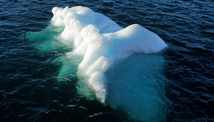
However, their route is restricted by the Antarctic Exclusion Zone (AEZ), an area that participants cannot sail into due to the constant risk of ice formations. The AEZ is a vast area that surrounds the Antarctic continent and takes into account the presence of all known ice.

Participants are not allowed to sail past the northern limit of the AEZ at a latitude of between 43 and 59 degrees South Latitude. The main reason for organizers to set this limit is to prevent skippers and their boats from finding themselves in waters in which icebergs and other ice formations (growlers) drift dangerously above and below the water level and to avoid as much as possible the risk of any collisions.
While icebergs are huge floating masses of ice and may be spotted visually or by radar, the same can’t be said about growlers which are blocks that detach from smaller glaciers that normally emerge no more than one metre above sea level. They are difficult to identify or even see as they are near impossible to spot in rough seas.
The size of the AEZ will be defined by organizers depending on the seasonal displacement of known ice for 2023. Companies such as CLS (Collect Localization Satellite) and others track the movement and record the position of icebergs.
The limit of all known ice can be estimated based on the information gathered by these companies, combined with other parameters such as sea water temperature, a good predictor of the possible presence of drifting icebergs.
Typically the AEZ is located approximately between 029º W to 048º E with a northern limit at Lat 43º S, from 048º E to 070º E with a northern limit at Lat 50º S, from 070º E to 118º E with a northern limit at Lat 46º S, from 118º E to the antimeridian with a northern limit at Lat 56º S, from the antemeridian to 133º W with the limit at Lat 53º S, from 133º W to 068º W with limit Lat 59º S, from 068º W to 029º W at Lat 49º S.
The exact coordinates of the AEZ will be specified in the sailing instructions before the event. Avoiding high-risk areas for participants is important to reduce the risk of collisions and consequent need for rescue at high latitudes.
Skippers must take into account these restrictions and comply with the regulations set by organizers. Their actions and decisions, even if taken under their own responsibility, can have a significant impact on other people, such as fellow skippers, organizers, rescue teams, etc.
The AEZ “lengthens” the total route to be sailed. Obviously, as the Earth is a globe, the further south you go, the fewer miles you have to sail. In certain circumstances, the AEZ may even prevent participants from taking advantage of the more favorable wind conditions they would find if they sailed a bit further south. However, it all must be balanced with the risk of finding floating ice.
Everything has a limit, and in this case it’s the limit set by organizers with the definition of the AEZ for the safety of the skippers and everyone involved in the GSC, following the same criteria with which boat safety parameters and participants’ training requirements are set.

Related Posts
Tim Kent enters Global Solo Challenge →

Returning with unfinished business →
When learning to sail includes the world →