
Zen and the Paper Navigational Chart
Published on December 15th, 2023
Depending on your age, shifting to electronic navigation has either been a process or all you know. Patrick Kelly with RCR Yachts discusses the process in this report:
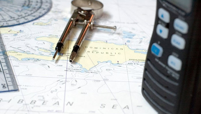
It seems like a lifetime ago, but during my high school and early college days I worked at a local West Marine store. One of my favorite things to do was talk with customers about their boating plans and the journeys they had taken (which is still true today!)
The store had a large chart table that was properly stocked with parallel rules, dividers, and a good assortment of charts, and the times spent plotting courses and exploring on paper all the places one could go was fascinating.
Goodbye Paper?
In those days, electronic chart plotters were new technology, and in addition to being of a gargantuan size, they were also quite expensive and functionally limited when compared to the plotters available today. Originally, paper charts were digitized as either raster or vector scans (more on that later), and available in chip format, like how electronic navigational charts (ENCs) are packaged today.

At that time, despite the availability of ENCs, paper charts were still required equipment aboard, and your options included individual charts, chart booklets, or chart almanacs for larger areas of operation. Even if you sprung for the latest and greatest technology of the time, you still needed to carry paper.
Now, I love paper charts and think that as a matter of good seamanship everyone should at least be familiar with basic course plotting, symbol recognition, and establishing a fix, but having all the paper charts you need aboard, especially if you log serious miles over long passages, can be cumbersome and rather expensive.
This notion was also reflected in the current version of the SOLAS (Safety of Life at Sea) treaty, which requires newly constructed ships greater than 500 gross tons to be outfitted with an Electronic Chart Display Information System (ECDIS) and to use official ENC products in the waters in which they operate.
In 2014, the National Oceanic and Atmospheric Administration (NOAA) announced that the US government would no longer print and distribute paper nautical charts. Instead, charts could be ordered and printed through a retailer.
In 2016, the US Coast Guard updated its requirements related to the carriage of charts aboard. The state of the ENC technology, likely coupled with the notion that large ships were already using ENCs for primary navigation, removed the requirement that charts carried aboard be made from paper, provided the ENCs in use were from official sources.
Then in 2019, NOAA announced the sunsetting of the paper and raster chart formats and devoted their resources instead to the refinement of their vector ENC product and align it with the latest International Hydrographic Data Model standard.
Raster vs Vector
The way in which a paper chart is displayed on a screen is related to the way in which the data is formatted. A raster nautical chart (RNC) is essentially a digital scan of a paper chart that can be displayed electronically. It has all the features of the original paper chart, and the user can pan and zoom about the chart with controls on the plotting device—it has the look and feel of a paper chart, and this is appealing to many users.
Because it is a scan, however, there are compromises in image resolution. Text features may sometimes appear sideways or difficult to read, and it is sometimes necessary to declutter the information that appears on the screen to see a clearer picture. Importantly, using RNCs requires adherence to the Local Notice to Mariners issued regularly by the USCG to be informed of anomalies or changes to the area defined by the chart.
A vector navigational chart (ENC), on the other hand, is a chart derived from a database of information that is presented mathematically through pixels on the screen. Because of this, much more data can be displayed in this format, and overlapping chart areas that may have had differing scales can be smoothed and seamlessly integrated.
ENCs have a slightly different look, but unlike RNCs, chart features such as marinas, aids to navigation, etc. can be highlighted and investigated for more specific information. You can zoom in to see layers of detail nearer your vessel or zoom out to see the path ahead.
Using these charts does require a little practice—the 2015 grounding of a Volvo Ocean Race competitor in the middle of the Indian Ocean due to user error is a specific example of how having this equipment carries with it the importance of knowledgeable use of it.
ENCs, depending on their manufacturer, can be updated regularly to ensure irregularities are included on the latest version, and although the plotter you use may have specific sources of charts, the data they display is basically the same.
The Move to ENC
With its decision to move to electronic charts, NOAA developed a multi-year plan to re-scheme its library of charts to ENCs that meet the latest international data standard. Known as S-100, this standard includes the ability of the charting database to include a wealth of currently-available data, as well as the capability to display additional information as future needs may determine.
To achieve this, NOAA begins with the original chart data and undertakes a process called “gridding.” Here, chart scales are standardized, edges of chart areas are matched to ensure seamless transition, and data on all charts are compiled and “layered” so that as the zoom level is manipulated, more or less information is displayed. In essence, the closer in you zoom, the more detailed the chart becomes.
Next, the chart undergoes metrification. The chart data is converted to metric units (used in the rest of the world) to comply with the standard. If you are reading this and having flashbacks to middle school when you were trying to convert metric measurements to standard units on your fingers, don’t worry—your plotter can be configured to do this for you—just pick the units you like best!
The good news is that the sources of depth information are updated and based on the latest bathymetric data, which is a vast improvement from the way these data were originally obtained. When you zoom in more closely in a harbor, you will see greater amounts of depth contour—a real benefit to vessel safety!
Lastly, transportation features and topographical contours are included in the database. While RNCs typically featured some topography, many ENCs do not. This additional capability will enhance situational awareness as these charts become more widely available. Finally, the timeline for this work to be completed is set for 2026.
While all ENCs currently available meet an acceptable international standard, the charts to come will be even more capable. Currently, NOAA has reschemed a good portion of the upper Great Lakes, Gulf Coast, and some of the east coast. You can check on the latest rescheming status on NOAA’s Status View Page.
Charts on Computers
Since ENCs are generated from database information, they can be displayed on all kinds of software platforms. You can even download chart readers on your PC or Mac, install the chart files, and plan your next voyage from your home or office. And if you still really love your paper charts, don’t worry!
The Office of Coast Survey has a portal through which you can select and print your own paper navigational charts for areas of navigation that you choose. Check out NOAA Custom Chart Version 2.0 and its related guides to get started!
Improvements in technologies available to boaters have made boating safer, more accessible, and ultimately more fun. Additionally, these technologies have become even more affordable and in many cases are standard equipment on new boats.
The original US navigation charts were commissioned by Thomas Jefferson in 1807, and the work begun centuries ago to ensure the safety of navigation continues today, buoyed by the power of better technology. The only thing left to do now is plan a boat trip to someplace spectacular! See you out there…

Related Posts
How I set up instruments offshore →
Underwear and other regatta necessities →
Thirteen ways to go faster offshore →
 We’ll keep your information safe.