
Tuesday: Weather forecast for Key West Race Week
Published on January 21st, 2014
Quantum Key West 2014 has attracted 129 entrants for a full week of racing (Jan. 20-24) in Key West, FL. Located at the southernmost tip of the continental United States, and just 90 miles from Cuba, having a handle on the weather is a challenge and a key to success at this elite event. Here is the weather forecast prepared by Sailing Weather Service issued 0715 LT 21 January 2014…
WARNINGS AND ADVISORIES: There are no active warnings or advisories posted for the sailing area today. Conditions can change quickly. Please monitor NOAA All Hazards Radio on your VHF for the latest official warnings and advisories from The National Weather Service.
SYNOPSIS: It appears we got the light air day out of the way yesterday, with the rest of the week looking sailable, with moderate to fresh breezes. Today we will see winds averaging stronger than yesterday, though wind speeds will be unstable – ranging light to moderate.
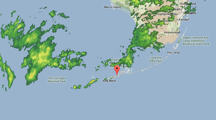
On the morning weather map, our focus is on a low pressure deepening over North Carolina. This low will move off the east coast today and become a Nor’easter Snow Storm for the northeast US. A cold front associated with this low is moving southeast across the Gulf this morning. The front will work its way into the waters north of Key West by this evening, and then pass across Key around or shortly after midnight tonight.

Today’s conditions will be pre-frontal, with unstable SW to W gradients with increased moisture and a good chance of showers over the sailing area. The rain is not expected to be extensive, but will add to the instability of the wind.
Arrival of showers this morning will mix right-shifted momentum from aloft down to the surface, so looking for building and right-shifting winds this morning through about early-afternoon. Then, there may be a period of transition mid-afternoon with lighter winds and equal chances of left and right-shifting breeze. By later afternoon, W/NW gradient will start to develop and increase winds, but this may not be until after sailing is done for the day.
CURRENT CONDITIONS: Mainly light SSW/SW winds 4-8 knots are reported around the area this morning. Winds have shown a slight right trend and build most recently. This trend is expected to continue.
Satellite shows extensive cloud cover just north of Key West, and radar confirms showers within this area as well. The clouds and showers are mainly moving west to east and staying north of Key West at the moment, but should expand south in the next few hours likely impacting the area mid-/late-morning.
FORECAST DISCUSSION: SSW/SW 5-10 at first. A right trend toward the W is expected mid/late-morning along with a build 10-15 knots. Some briefly stronger gusts are likely with the arrival of any showers, with 20 knots possible but this should be short-lived. Moderate winds 11-15 knots likely though early afternoon. Then a period of easing winds likely mid-afternoon 6-10 knots. By late afternoon, a trend toward the right and W/NW developing/increasing again 10-15 kts, but this may hold off until after sailing is done for the day.
WEATHER: Partly to mostly cloudy this morning. Chance of showers arriving from the southwest/west this morning. Risk of rain showers is 70%. Scattered showers will continue into the afternoon, arriving from the west/northwest. A period of drying is possible this evening before another area of showers arrive just ahead of the approaching cold front overnight.
TEMPERATURE: Fairly steady temperatures from near 70F this morning, to mid-70sF this afternoon.
SEAS: Wind waves mainly 1-2 ft. A slight SW swell up to 2 ft is possible.
Detailed Wind Forecast:
Time Wind Speed Wind Direction (MAG)
(LT) Mean Range Mean Range
0800 07 05-10 200 185-240
0900 09 07-11 230 210-250 …watch for showers arriving from wwest
1000 12 09-15 260 245-280
1100 15 12-18 280 265-270 …gusts tto 20 possible w/ showers
1200 14 12-16 275 260-295
1300 11 09-14 270 255-290 …easing and becoming unstable
1400 08 06-11 230 220-270 …possibly quite patchy
1500 08 06-11 235 250-275
1600 10 08-12 255 260-280 …watch for right trend and build
1700 12 10-14 290 260-310
1800 14 12-16 300 260-320
HEDGE: FORECAST CONFIDENCE: AVERAGE
1) The models are in reasonably good agreement considering the uncertain behavior of winds around rain cells. I have used wider ranges in both the speed and direction columns to reflect uncertainty related to showers.
2) For sure, passing showers will force winds outside of predicted ranges at times today. The forecast table reflects the model consensus.
3) The light patch and left trend 1300-1500 is by no means a sure thing. Again this is a model consensus but much of it depends on the behavior of shower cells around the area.
4) Rain cells will be pushing wind. Watch for winds to shift and increase from the direction of any approaching cells. As the cells pass east, winds will likely ease could become highly variable in direction. There is a chance of brief calm patches following any rain, especially 1300-1500. However calms/easing will be short-lived with a return of the gradient wind over time.
5) Overall, this is a dynamic scenario. I do not expect a consistent side to pay, unless showers favor one side of the course area or the other. General strategy should be to monitor cloud/rain cell movement closely, and sail toward any approaching raining clouds for a favored shift and build. However, be aware that winds will die off as the cells pass.
6) Late this afternoon, the gradient trend will likely overwhelm and shower impacts, so right-trending and increasing breeze will be the dominant factor. Unfortunately, this more predictable and consistent trend may not appear until after sailing is done for the day.
***************************************************************
OUTLOOK FOR WEDNESDAY (22 January 2014)
Wednesday will likely be the windiest day of the regatta, as post-frontal gradients will be fresh while cold high pressure moves into the northern Gulf of the Mexico in the wake of the front. Strongest winds are expected to be in the immediate wake of the front, probably before sunrise. N’ly gradients will start to gradually ease in the morning, moderating winds for the afternoon’s sailing.
Detailed Wind Forecast:
Time Wind Speed Wind Direction (MAG)
(LT) Mean Range Mean Range
0800 20 18-23 340 330-360 …gusts to 25 likely
1000 18 16-22 350 340-005
1200 17 15-20 355 345-010
1400 16 14-19 360 350-010
1600 16 13-18 005 350-015
1800 15 13-18 010 355-020
SEAS: Rough to very rough sea conditions are expected in the morning, with roughest seas away from the Keys to the south. Waves likely 3-5 ft in the morning. Seas will gradually moderate with time in the afternoon as winds relax, decreasing seas to 2-4 ft and possibly less by later afternoon.
TEMPERATURE RANGE: Much cooler. Near 60F / Mid 70sF
WEATHER: Some clouds and showers possible early morning. Becoming mainly sunny and – as noted – much cooler/drier.
***************************************************************
OUTLOOK FOR THURSDAY (23 January 2014)
Weakening high pressure moves across FL, with moderating winds and seas veering NE/E with time.
WIND: NE/ENE 8-13 in the morning, possible 11-15 for a time. Winds may veer further to ENE/E in the afternoon.
SEAS: 2-3 ft.
TEMPERATURE RANGE: Mid-50sF / Near 70F
WEATHER: Mainly sunny. Some cumulus cloud offshore over the Gulf Stream in the AM. Cumulus develop on the upper keys in the afternoon and may drift offshore toward the course areas PM.
***************************************************************
OUTLOOK FOR FRIDAY (24 January 2014).
Arctic High pressure moves in the southern plains with a ridge extending east to the Gulf coastal states. This will reinforce the N/NE gradient, with stronger NE winds returning. The gradient will veer in the afternoon and an easing trend is forecast.
WIND: NNE/NE building 15-20 knots through late morning with some stronger gusts possible. Veering NNE/NE and easing 13-18 kts in the afternoon.
SEAS: Rough up to 3-5 ft in the morning, moderating 2-4 ft in the afternoon.
TEMPERATURE RANGE: Near 60F / Near 70F
WEATHER: Some scattered to broken cloud in the morning with a very slight chance of showers early AM. Then becoming mostly sunny.

Related Posts

Pics or it didn’t happen →

Drunk man steals tiki hut bar →

Key West racing is back →

 We’ll keep your information safe.