

Volvo Ocean Race: When Experience Counts
Published on April 15th, 2015
You may not need a weather man to know which way the wind blows, as Bob Dylan sang, but knowing which way the wind blows before it blows is a critical skill in offshore racing. Now with the one design nature of the 2014-15 Volvo Ocean Race, this skill is contributing to the order in the fleet. Will Oxley, navigator on Team Alvimedica, explains…
Among the areas where the experienced teams have an advantage is recognizing weather situations, and that’s something that comes with practice. The guys on the front boats that have been around multiple times have a major advantage.
There are lessons that you have to learn when you’re going, “We need to go this way, 70 degrees against the shift, because I think that cloud is going to rain and there’s a shift that’s going to come back and then it’s going to roll us otherwise.” You have to experience that a few times the hard way to believe me.
My primary role as navigator is to keep the boat safe. But then, my secondary role is to interpret the weather as best as possible to provide the information to get the boat as quickly as possible to where we’re trying to go. The two primary navigation programs that I’m using are Adrena and Expedition. I’m running them concurrently on different machines.

When there’s rain around, we’re using the radar to help us locate the cells and get an accurate bearing on them. We’re using Squid, which is provided to us by the race, and that has access to detailed satellite images. So when it’s one of those tricky situations, we’re downloading, at least hourly, satellite images to try and get a sense of the direction that the big picture is moving and what’s going on.
We also have access to METARs, which is predominantly used by pilots. When we’re coastal, we can get the airport weather reports, so we’re able to verify what’s going on, to help calibrate against the GRIB files. It’s a great pity about the QuikSCAT satellite, in which the United States was a wonderful contributor, but when the instrument went down on that satellite, that was a great loss to sailing.
Now we’re using a European version but it’s a lot patchier. We get a couple of passes a day, though hardly over of the top of us, but nonetheless provides data that when accurately lined up with the GRIB and the satellite pictures, our confidence grows.
We also have access to synoptic maps and in different parts of the world, they’re good and sometimes they’re not. But I’m a big fan of being able to start with the synoptic map, then look at the satellite picture, get an understanding of the driving forces, and then drill down from there.
A good day is when all the information is in sync and the information is consistent. The challenging decisions are when there is conflict amidst the information.
Race website – Tracking – Scoreboard – Videos – Route
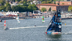
Background: The 2014-15 Volvo Ocean Race began in Alicante, Spain on Oct. 11 with the final finish on June 27 in Gothenburg, Sweden. Racing the new one design Volvo Ocean 65, seven teams will be scoring points in 9 offshore legs to determine the overall Volvo Ocean Race winner. Additionally, the teams will compete in 10 In-Port races at each stopover for a separate competition – the Volvo Ocean Race In-Port Series. The sixth leg, from Itajaí, Brazil to Newport, USA (5,010 nm), begins April 19 with an ETA of May 6.

Related Posts
Pirates in the Indian Ocean →
The Ocean Race Europe begins in Kiel →
Challenges, triumphs, and team spirit →
 We’ll keep your information safe.