

Hurricane Irma Gains Strength
Published on September 5th, 2017
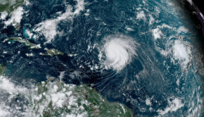
(September 5, 2017) – Category 5 Hurricane Irma has become one of the strongest storms recorded in the Atlantic, and is threatening to slam into Caribbean islands including Puerto Rico and the Virgin Islands with “potentially catastrophic” force tomorrow, with the likelihood of Florida by the weekend.
Here’s the update (500 PM AST Tue Sep 05 2017) from the National Hurricane Center:
POTENTIALLY CATASTROPHIC CATEGORY 5 HURRICANE IRMA NEARING THE NORTHERN LEEWARD ISLANDS…
…WEATHER CONDITIONS WILL DETERIORATE OVER THE NORTHERN LEEWARD ISLANDS SOON…
SUMMARY OF 500 PM AST…2100 UTC…INFORMATION
———————————————-
LOCATION…17.1N 59.8W
ABOUT 130 MI…210 KM E OF ANTIGUA
ABOUT 135 MI…220 KM ESE OF BARBUDA
MAXIMUM SUSTAINED WINDS…185 MPH…295 KM/H
PRESENT MOVEMENT…W OR 280 DEGREES AT 15 MPH…24 KM/H
MINIMUM CENTRAL PRESSURE…926 MB…27.35 INCHES

WATCHES AND WARNINGS
——————–
CHANGES WITH THIS ADVISORY:
The government of the Dominican Republic has issued a Hurricane Warning along the north coast of the Dominican Republic from the border with Haiti eastward to Cabo Engano. A tropical storm warning has been issued for the south coast of the Dominican Republic from south of Cabo Engano westward to the southern border with Haiti.
SUMMARY OF WATCHES AND WARNINGS IN EFFECT:
A Hurricane Warning is in effect for…
* Antigua, Barbuda, Anguilla, Montserrat, St. Kitts, and Nevis
* Saba, St. Eustatius, and Sint Maarten
* Saint Martin and Saint Barthelemy
* British Virgin Islands
* U.S. Virgin Islands
* Puerto Rico, Vieques, and Culebra
* Dominican Republic from Cabo Engano to the northern border with
Haiti
A Hurricane Watch is in effect for…
* Guadeloupe
* Haiti from the northern border with the Dominican Republic to Le Mole St. Nicholas
* Turks and Caicos Islands
* Southeastern Bahamas
A Tropical Storm Warning is in effect for…
* Guadeloupe
* Dominica
* Dominican Republic from south of Cabo Engano westward to the southern border with Haiti
A Tropical Storm Watch is in effect for…
* Haiti from south of Le Mole St. Nicholas to Port-Au-Prince
A Hurricane Warning means that hurricane conditions are expected somewhere within the warning area. A warning is typically issued 36 hours before the anticipated first occurrence of tropical-storm-force winds, conditions that make outside preparations difficult or dangerous. Preparations to protect life and property should be rushed to completion.
A Tropical Storm Warning means that tropical storm conditions are expected somewhere within the warning area.
A Tropical Storm Watch means that tropical storm conditions are possible within the watch area, generally within 48 hours.
Interests elsewhere in the Dominican Republic and Haiti, as well as Cuba, the central and northwestern Bahamas, and Florida should monitor the progress of Irma.
For storm information specific to your area in the United States, including possible inland watches and warnings, please monitor products issued by your local National Weather Service forecast office. For storm information specific to your area outside the United States, please monitor products issued by your national meteorological service.
DISCUSSION AND 48-HOUR OUTLOOK
——————————
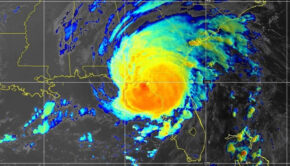
At 500 PM AST (2100 UTC), the distinct eye of Hurricane Irma was located near latitude 17.1 North, longitude 59.8 West. Irma is moving toward the west near 15 mph (24 km/h). A turn toward the west-northwest is forecast to begin tonight and continue for the next couple of days. On the forecast track, the extremely dangerous core of Irma will move over portions of the northern Leeward Islands tonight and early Wednesday, move near or over portions of the northern Virgin Islands Wednesday, and pass near or just north of Puerto Rico late Wednesday and Wednesday night.
Maximum sustained winds are near 185 mph (295 km/h) with higher gusts. Irma is an extremely dangerous category 5 hurricane on the Saffir-Simpson Hurricane Wind Scale. Some fluctuations in intensity are likely during the next day or two, but Irma is forecast to remain a powerful category 4 or 5 hurricane during the next couple of days.
Hurricane-force winds extend outward up to 60 miles (95 km) from the center and tropical-storm-force winds extend outward up to 175 miles (280 km).
The estimated minimum central pressure is 926 mb (27.35 inches).
HAZARDS AFFECTING LAND
———————-
STORM SURGE: The combination of a life-threatening storm surge and large breaking waves will raise water levels ABOVE NORMAL TIDE LEVELS by the following amounts within the hurricane warning area near and to the north of the center of Irma. Near the coast, the surge will be accompanied by large and destructive waves.
Northern Leeward Islands…7 to 11 ft
Turks and Caicos Islands…15 to 20 ft
Southeastern Bahamas…15 to 20 ft
Northern coast of the Dominican Republic…3 to 5 ft
Northern coast of Haiti and the Gulf of Gonave…1 to 3 ft
The combination of a life-threatening storm surge and the tide will cause normally dry areas near the coast to be flooded by risin gwaters moving inland from the shoreline. The water is expected to reach the following HEIGHTS ABOVE GROUND if the peak surge occurs at the time of high tide…
British and U.S. Virgin Islands except St. Croix…7 to 11 ft
Northern coast of Puerto Rico…3 to 5 ft
Southern coast of Puerto Rico and St. Croix…1 to 2 ft
The deepest water will occur along the immediate coast in areas of onshore winds, where the surge will be accompanied by large and destructive waves. Surge-related flooding depends on the relative timing of the surge and the tidal cycle, and can vary greatly over short distances. For information specific to your area, please see products issued by your local National Weather Service forecast office.
WIND: Hurricane conditions are expected within the hurricane warning area in the Leeward Islands tonight, with tropical storm conditions beginning within the next few hours. Hurricane conditions are expected to begin within the hurricane warning area in the British and U.S. Virgin Islands and Puerto Rico on Wednesday, with tropical storm conditions beginning tonight. Hurricane conditions are expected to begin within the hurricane warning area in the Dominican Republic early Thursday, with tropical storm conditions beginning Wednesday night.
Hurricane and tropical storm conditions are possible within the watch area in Haiti, the Turks and Caicos Islands, and the southeastern Bahamas by early Thursday.
RAINFALL: Irma is expected to produce the following rain accumulations through Thursday:
Northern Leeward Islands…8 to 12 inches, isolated 20 inches
Northeast Puerto Rico and the British and U.S. Virgin Islands except St. Croix…4 to 10 inches, isolated 15 inches
Southwest Puerto Rico, the southern Leeward Islands, and
St. Croix…2 to 4 inches
Irma is expected to produce the following rain accumulations Wednesday through Saturday:
Southeast Bahamas and Turks and Caicos…8 to 12 inches, isolated 20 inches
Northern Dominican Republic and northern Haiti…4 to 10 inches, isolated 15 inches
Southwest Haiti…1 to 4 inches
These rains could cause life-threatening flash floods and mudslides.
SURF: Swells generated by Irma will affect the northern Leeward Islands, Puerto Rico, the Virgin Islands, the southeastern Bahamas, the Turks and Caicos Islands, and the northern coast of the Dominican Republic during the next several days. These swells are likely to cause life-threatening surf and rip current conditions. Please consult products from your local weather office.
NEXT ADVISORY
————-
Next intermediate advisory at 800 PM AST.
Next complete advisory at 1100 PM AST.

Related Posts
Is your name on the 2024 storm list? →
Are alarm bells beginning to go off? →
‘Extremely active’ 2024 hurricane season →
 We’ll keep your information safe.