Mapping movements of icebergs
Published on December 21st, 2014
While sailing south of Africa on an around-the-world voyage, Matteo Miceli was suddenly alerted to a massive iceberg in his path.
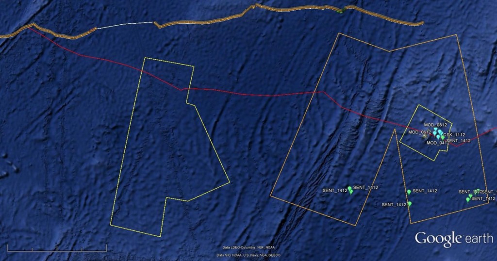
Almost 4 km long, the iceberg drifting near the Prince Edward Islands was detected and tracked by European satellites.
“According to our experience, at these latitudes the big icebergs undergo strong fragmentation. The presence of a big iceberg could be an indicator for a field of smaller fragments which could be very dangerous for the boat,” said Luca Pietranera from e-GEOS, a satellite data processing company that provides information to the team planning Matteo’s route.
Radar imagery from ESA’s Sentinel-1A satellite and the Italian space agency’s Cosmo-SkyMed were used to track the movement of the iceberg – and guide Matteo away from the treacherous waters.

The benefit of radar is that it can see through clouds and in the dark, and can therefore provide regular updates on the positions of the icebergs.
It may seem like an awfully cold place for a sailing trip, but Matteo is attempting to sail the Eco40 non-stop around the world using only renewable energy in a project called ‘Roma Ocean World’, technically lead by the ‘La Sapienza’ University of Rome. Even his food supply is self-sufficient.
The aim is to demonstrate how modern technology, together with a responsible attitude, allows us to enjoy maritime sports while respecting the environment.
During the voyage, information on the changes taking place on land and at sea are being collected, underlining the importance of monitoring the effects of climate change on our planet.
In addition, measurements on wind and waves are being used to check satellite data. Today, Matteo is in the Indian Ocean.
“In terms of iceberg hazards, the most dangerous part of the Eco40 route will be the passage south of Cape Horn, foreseen in February. For this reason, tracking of the big iceberg there has already started,” said Mr Pietranera.
The 32 km-long iceberg drifting along the boat’s projected route near the South Georgia and the South Sandwich Islands in the South Atlantic has already been picked up on the satellite radars.
In the coming months, Sentinel-1A will continue to cover this and other obstacles during Matteo’s endeavour.
The Sentinel-1 mission was developed for Europe’s Copernicus environment monitoring programme and provides an all-weather, day-and-night supply of imagery of Earth’s land, oceans and ice.
Launched in April, Sentinel-1A passes over the same spot on Earth every 12 days. Once its identical twin, Sentinel-1B, is launched in 2016, this will be cut to just six days, so that changes such as the movements of icebergs can be mapped even faster.
Source: phys.org

Related Posts

Measuring impact of Olympic equipment →
How to deal with end-of-life vessels →

Are we reaching a tipping point? →