Rare Weather Event During Chicago-Mac
Published on August 7th, 2017
Competitors in the 109th Chicago Yacht Club Race to Mackinac got a gut punch when storm winds swept across Lake Michigan, with only 200 of the 297 starters completing the 289.4 nm course. Meteorologist Mark Thornton explains what happened.
After a challenging 2016 Chicago Mac (click here for a summary), this year’s competitors were likely hoping for an easier trip to the island. But as is often the case, Mother Nature wasn’t inclined to cooperate.
Although the race started in pleasant sailing conditions, a rare weather phenomenon known as a heat burst, or dry microburst, caused two separate and frightening incidents late on Saturday night (July 15). The one-two punch of Saturday’s heat burst, combined with brisk northerly winds following the passage of a cold front on Sunday, caused a third of the fleet to retire from the race.
The Forecast
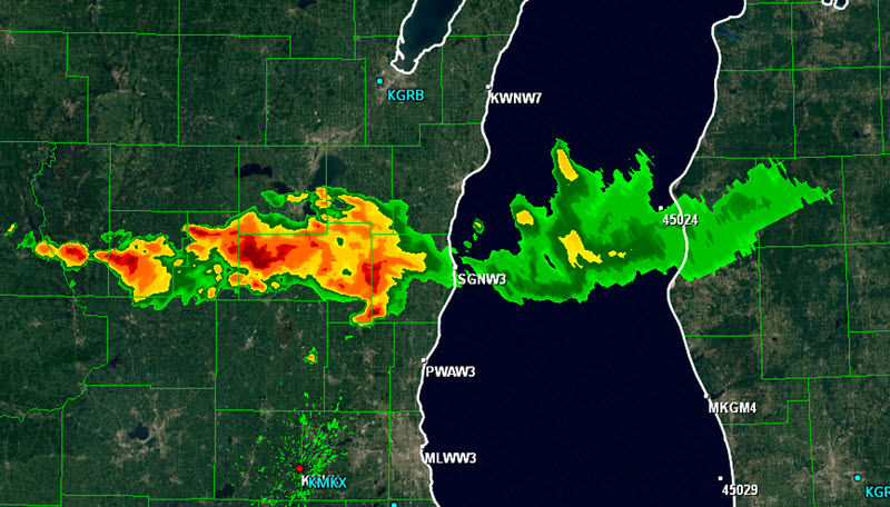
At 10:00 am on Saturday morning , a cold front extending from a low in northeastern Canada was located just north of Lake Superior (Figure 1). This frontal boundary was expected to sweep down Lake Michigan, reaching its southern shore by mid-morning on Sunday (click here for forecast).

Typical of cold fronts, its passage down the lake was expected to produce a veering of the wind from southwesterly to northerly, increase wind speed and wave heights, and raise the potential for thunderstorms. The Open Lake Forecast from the Chicago National Weather Service office published at 9:00 am on Saturday morning stated:
Northern Lake Michigan:
REST OF TODAY…Southwest winds 10 to 15 kt increasing to 15 to 20 kt. A few afternoon gusts to 25 kt. Chance of showers and thunderstorms this afternoon. Waves 1 to 3 ft building to 3 to 5 ft by mid afternoon.
TONIGHT…Southwest winds 10 to 20 kt veering sharply to north 15 to 25 kt late in the evening. Chance of gusty showers and thunderstorms in the evening…then slight chance of showers and thunderstorms early overnight. Waves 3 to 5 ft.
SUNDAY…North winds 15 to 25 kt. Waves 4 to 6 ft occasionally to 8 ft.
SUNDAY NIGHT…North winds 15 to 25 kt becoming northeast 10 to 15 kt by overnight. Waves 3 to 5 ft subsiding to 2 to 4 ft.
Southern Lake Michigan:
REST OF TODAY…Northwest winds around 10 kt becoming west 10 to 15 kt late this morning…becoming southwest 10 to 20 kt early this afternoon…then becoming south late. Waves 1 to 3 ft.
TONIGHT…Southwest winds 10 to 20 kt veering sharply to north 15 to 25 kt late. Chance of gusty showers and thunderstorms late this evening and overnight. Waves 1 to 3 ft this evening building to 2 to 4 ft overnight.
SUNDAY…North winds 15 to 25 kt increasing to 30 kt by late morning. Waves 4 to 7 ft occasionally to 9 ft.
SUNDAY NIGHT…North winds to 30 kt becoming northeast 10 to 20 kt overnight. Waves 4 to 7 ft occasionally to 9 ft subsiding to 3 to 6 ft occasionally to 8 ft overnight.
But it turned out to be much more…. full report.

Related Posts

What is an offshore sailboat race? →
AIS required for Chicago Mackinac Race →

Tale of two rescues →