Hurricane Harvey a Catastrophic Threat
Published on August 25th, 2017
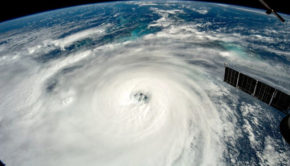
(August 25, 2017) – Hurricane Harvey continues to intensify and will likely be the nation’s first Category 3 landfall in almost 12 years tonight or Saturday morning, poised to clobber the Texas Gulf Coast with catastrophic rainfall flooding, dangerous storm-surge flooding and destructive winds this weekend that could leave parts of the area uninhabitable for an extended period of time.
After a slight pause overnight, Harvey has intensified with maximum sustained winds of 110 mph. Harvey is located just over 100 miles southeast of Corpus Christi, Texas, moving northwest at around 10 mph.
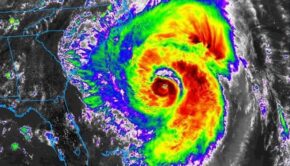
Harvey’s central pressure has plummeted once again Friday morning, approximately another 20 millibars in just a few hours as another rapid intensification phase kicks in.
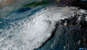
Outer rainbands are already spiraling ashore as far north as the upper Texas coast, bringing brief heavy rain and gusty winds.

Tropical storm-force winds are already nearing the Coastal Bend of Texas, with 30 mph sustained winds reported at the Corpus Christi Naval Air Station, according to the National Hurricane Center.
Water levels were already 1 to 2 feet above average tide levels as of Friday morning from S. Padre Island, Texas to Calcasieu Pass, Louisiana.
A hurricane warning has been issued for a portion of the Texas coast, from north of Port Mansfield to Sargent, including the city of Corpus Christi. A hurricane warning means hurricane conditions are likely within the watch area. In this case, hurricane conditions are likely within 12 to 24 hours.
Importantly, tropical storm-force winds may begin to affect the hurricane-warned area above as soon as late Friday morning, making final preparations difficult.
Tropical storm warnings are in effect from north of Sargent to High Island, Texas, including the cities of Houston and Galveston. Tropical storm warnings are also in effect from north of Port Mansfield to the mouth of the Rio Grande River.
The NHC also issued its first-ever public storm surge warning, which includes a swath of the Texas coast from Port Mansfield to High Island. This means a life-threatening storm surge is expected in the warned area in the next 36 hours. This warning does not include Galveston Bay, but does include Galveston Island and the Bolivar Peninsula.
With a favorable environment that includes deep, warm Gulf of Mexico water, and low wind shear, Harvey will continue to strengthen, and will likely be a Category 3 hurricane at landfall along the Texas coast overnight Friday night or early Saturday morning.
After making landfall, Harvey will be caught in a zone of light steering winds aloft that will stall the circulation for more than two days.
Once moving again, potentially by Monday, Harvey’s center may re-emerge over the Gulf of Mexico, opening up the possibility of some strengthening before a final landfall in Louisiana. But that remains highly uncertain, as stalled or slow-moving tropical cyclones are notoriously difficult to forecast.
The projected path shows the expected track of the circulation center. Impacts such as heavy rain and storm surge can extend beyond this forecast path.
This would be the nation’s first Category 3 or stronger hurricane landfall since Hurricane Wilma struck south Florida in October 2005, an almost 12-year run.
Harvey may also be the strongest landfall in this area known as the Texas Coastal Bend since the infamous Category 3 Hurricane Celia hammered the Corpus Christi area in August 1970 with wind gusts up to 161 mph, damaging almost 90 percent of the city’s businesses and 70 percent of its residences and destroying two hangars at the city’s airport.
Harvey will bring a mess of coastal impacts, including storm-surge flooding, high surf with battering waves and damaging winds. With Harvey stalling for a few days, prolific rainfall, capable of catastrophic flash flooding will result near the middle and upper Texas coast.
For now, areas near the Texas and southwest Louisiana Gulf coasts are in the biggest threat area for torrential rainfall and major flash flooding, potentially including Houston and Corpus Christi.
Local National Weather Service offices have not minced words about the threat, warning of “some structures becoming uninhabitable or washed away” and “numerous road and bridge closures with some weakened or washed out”, with record river flooding expected in some areas.
Harvey’s heavy rain may not entirely exit the areas of Texas it soaks until sometime next Thursday, and may not exit the Mississippi Valley until next Friday.
Among the biggest uncertainties is the heavy rain potential in central Texas, including for the flood-prone cities of Austin and San Antonio. That all depends on how far inland and to the west Harvey tracks and how long it stalls in that area. Flash flood watches have been issued for much of southeast, southern, and parts of central Texas.
According to the National Weather Service, structural damage to buildings near the coast is expected, with “many washing away”. Battering waves riding atop the surge will lead to “extreme beach erosion”, “massive damage to marinas, docks, boardwalks and piers” in the areas of highest storm surge.
Importantly, rising water will cut off near-shore escape routes and secondary routes before peak surge arrives.
Given Harvey’s expected slow crawl near the coast, at least some coastal flooding, along with battering waves, could persist for several days, over multiple tide cycles along the Texas and southwest Louisiana coast into next week.
This coastal flooding and wave action could increase if Harvey’s center re-emerges over the Gulf and intensifies, potentially leading to a second storm surge along parts of the Louisiana or upper Texas coast next week. Again, this part of the forecast is highly uncertain at this time.
Furthermore, this water rise from the Gulf of Mexico won’t allow rain-swollen rivers and bayous to drain, compounding the inland flood threat.
If that wasn’t enough, there’s the winds.
The National Weather Service warns of “structural damage to sturdy buildings” and “complete destruction of mobile homes”, where the eyewall of Harvey tracks.
Roads not already impassable by flooding may become blocked from downed trees or other debris. Power and communication outages will be widespread near and inland of the landfall in central and southeast Texas.
Furthermore, persistent winds, even if they are not particularly high-end if Harvey is over land, could down more trees than they otherwise would given the rain-soaked or flooded ground, possibly for several days as Harvey lingers.
Source: weather.com

Related Posts
2025 Hurricane Season Update →
Above-normal Atlantic hurricane season →
Uncertainty for 2023 Atlantic hurricanes →