
Obtaining NOAA paper nautical charts
Published on January 4th, 2020
The National Oceanic and Atmospheric Administration (NOAA) Office of Coast Survey is the nautical chartmaker of the USA. Originally formed by President Thomas Jefferson in 1807, Coast Survey updates charts, surveys the coastal seafloor, responds to maritime emergencies, and searches for underwater obstructions that pose a danger to navigation.
But the NOAA recently announced the start of a five-year process to end traditional paper nautical chart production.
While NOAA is sunsetting its traditional nautical chart products, it is undertaking a major effort to improve the data consistency and provide larger scale coverage within its electronic navigational chart (NOAA ENC®) product suite.
Over the next five years, NOAA will work to ease the transition to ENC-based products, such as providing access to paper chart products based on ENC data. The online NOAA Custom Chart prototype application enables users to create their own charts from the latest NOAA ENC data.

Users may define the scale and paper size of custom-made nautical charts centered on a position of their choosing. Users may then download, view, and print the output. The application is an easy way to create a paper or digital backup for electronic chart systems.
This webcast will provide an overview of the sunsetting process and a live demonstration of the NOAA Custom Chart prototype, including a discussion of the improvements that are planned for the prototype.
Date and time: Thursday, January 9, 2020, at 2 p.m. (EST)
How to register: https://attendee.gotowebinar.com/register/7410207397804043779

Related Posts
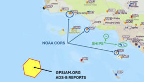
GPS interference off California →
The race to safeguard navigation →

Has technology ruined offshore racing? →