

That was then, This is now
Published on December 18th, 2025
Light and variable winds are shaping as a key feature of this year’s Rolex Sydney Hobart Yacht Race, with early forecasts pointing to a tactical opening phase rather than a flat-out drag race along the 628-nautical course.
The 80th edition begins December 26, and it’s looking to be a navigators race. For the esteemed Adrienne Cahalan, who first competed on the course in 1984, the job has come a long ways from paper charts, dividers, and a constant watch on the sky.
“There was no GPS,” Cahalan recalls. “I watched another navigator taking sextant sights. You really gain an appreciation for how people had to do it before digital navigation.”
Weather information came via high-frequency radio broadcasts, supplemented by experience and observation. Cloud formations were read as carefully as charts, offering clues about approaching fronts or settled high-pressure systems. Position-finding was labor-intensive, involving parallel rulers, compasses, tables, and manual plotting.

That world began to change in the early 1990s with the arrival of GPS.
“GPS shifted the navigator’s role,” Cahalan said. “Suddenly, you knew exactly where you were. That freed up time to focus more on tactics, boat performance and strategy.”
While location accuracy improved dramatically, weather information remained limited. Voice forecasts continued via radio, later joined by weather faxes that delivered synoptic charts on rolls of paper. The navigator still acted as the sole conduit of information on board.
The next major shift came in the early 2000s with the introduction of internet connectivity at sea, although access was heavily restricted.
“It was extremely expensive — something like $20 a megabyte,” Cahalan said. “You had to disable images and be very selective about what you downloaded.”
True real-time access did not arrive until the last few years, with the rollout of satellite broadband systems such as Starlink. For the first time, offshore crews could access the same tools available on land: live satellite imagery, radar, coastal observations and constantly updated weather models.
“You can sit out there now with so many tools at your fingertips,” Cahalan said. “But they’re a guide, not a decision-maker.”
Despite the explosion of data, she argues experience and intuition remain central to navigation.
“I’ve seen these scenarios before. You watch them unfold and remember what happened last time,” she said. “That’s something technology can’t replace.”
The rise of digital tools has also changed expectations. With weather apps and online models now available to anyone, navigators face greater scrutiny.
“The expectations on navigators have gone up,” Cahalan said. “People assume you should know everything, but we don’t have a crystal ball.”
At the same time, the wider access to information has made crews more informed and engaged, reducing reliance on a single source of knowledge on board.
Some older tools have disappeared almost entirely. Sextants, once essential, are now museum pieces.
“I haven’t had a sextant on a boat for 20 years,” Cahalan said. “I didn’t carry one on my last round-the-world race either.”
Paper charts, while no longer strictly necessary, still have a place.
“They’re useful as a visual reference,” she said. “People often grasp things more easily looking at a chart than at a screen.”
Modern navigation systems now resemble high-performance motorsport garages. Boats are equipped with sensors measuring speed, angle, pressure and sail shape, feeding sophisticated performance software that compares real-time data with forecast models.
“You’ve got sensors everywhere telling you what the boat is doing,” Cahalan said. “It’s incredibly computerized.”
That volume of information can be overwhelming. Knowing what to ignore has become as important as knowing what to analyze.
“You have to focus on what really matters and not chase every rabbit down a hole,” she said.
Through four decades of technological change, one element has remained constant.
“Communication hasn’t changed in 40 years,” Cahalan said. “The navigator still has to clearly explain the plan — what we’re trying to achieve and how we want to sail the boat. Computers can’t do that.”
As offshore racing continues to evolve, navigation has become faster, more precise and more data-rich than ever before — but at its core, the job still relies on judgement, experience and the ability to read both the ocean and the people on board.
Details – Entry list – Tracker
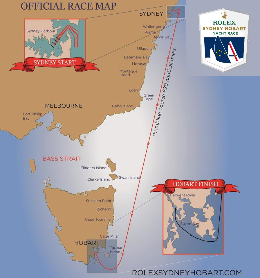
The 2025 Sydney Hobart Race extends 628-nautical miles from Sydney Harbour to Hobart, the state capital of Tasmania. The start on December 26 takes place in the heart of the Australian summer, with 142 entrants planning to take on the 80th edition.
Source: Steve Dettre/RSHYR

Related Posts
When imbalance is the topic →
First woman to win Sydney Hobart Race →

Demanding first night for Sydney Hobart →

 We’ll keep your information safe.