GPS interference off California
Published on July 1st, 2026
Previous generations relied on maps in their car, and charts on their boat, but today we push a button for directions. All good… until it isn’t. Can we still stay safe without technology? Read on…
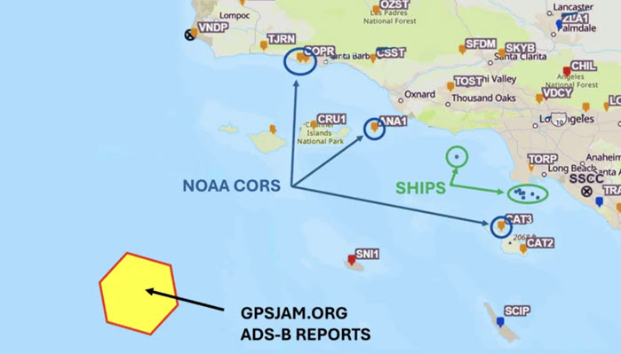
It was late at night on January 29, 2026. Seven ships approaching the Port of Long Beach from the west keyed their microphones on VHF Channel 14 to report GPS outages to the Los Angeles/Long Beach Vessel Traffic Service. Aircraft over the Channel Islands reported similar issues via ADS-B, while NOAA CORS sites recorded anomalies in L1 and L2 signal-to-noise ratios—all within the span of an hour.
While spoofing and jamming of global navigation satellite systems (GNSS) have become recurring problems in conflict zones, incidents like this demonstrate that no one is immune.
AIS reports from at least seven vessels showed position jumps consistent with GPS spoofing. At least one vessel’s AIS transmission ceased altogether for nearly an hour, likely because of an invalid GPS/GNSS position solution. Available data indicates the event affected an area spanning more than 100 miles, including the critical Los Angeles/Long Beach Traffic Separation Scheme. – Full report


Related Posts

Qatar suspends marine activities →

Marine graveyard in Miami →
The race to safeguard navigation →