
2018 Atlantic hurricane outlook
Published on April 4th, 2018
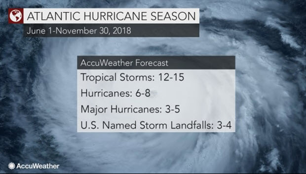
After a devastating hurricane season for the United States in 2017, AccuWeather.com forecasters are predicting a near normal to slightly above-normal year with between 12 to 15 tropical storms.
Of those storms, 6 to 8 are forecast to become hurricanes and 3 to 5 are forecast to become major hurricanes.
“Last year we had 17 tropical storms. This year may not be quite as active, but still probably normal to slightly above normal,” AccuWeather Atlantic Hurricane Expert Dan Kottlowski said.
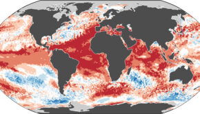
Similar to last year, sea surface temperatures are expected to remain warmer than normal across most of the basin and normal to above normal over the main developmental region, where more than 85 percent of all tropical storms form.

“Right now, we are in a weakening La Niña pattern, but the climate pattern is expected to go into what’s called a neutral pattern, which promotes near-normal wind shear,” Kottlowski said.
This should limit tropical development.
“The thing that’s causing the balance to tip in one direction [this year] is that sea surface temperatures are warmer than normal,” he said.
Warm water creates more favorable conditions for tropical development.
While last year brought six impacts to the United States, including Puerto Rico and the Virgin Islands, this year is more likely to result in three or four.
“This season may not [bring] as many impacts, but I’m almost afraid to tell people this because it only takes one big storm to hit you to cause massive damage,” Kottlowski said. “We saw that from Harvey, Irma and Maria last year. If all we had was just another Irma or Harvey, that would be more than enough to cause catastrophic damage for any coastal community.”
Some Atlantic basin seasons feature below average activity but still result in a devastating storm, like Hurricane Andrew in 1992, while others like 2010 — the third most active season on record — did not feature a hurricane making landfall.
According to Kottlowski, conditions are ripe for early season development in the Gulf of Mexico due the warm water already in place in that part of the Atlantic basin.
As for the rest of the season, historical records and the projected pattern suggest the area from Houston to Florida and up through the Outer Banks of North Carolina will be more favorable for direct impacts from tropical storms and hurricanes.
The 2018 Atlantic basin hurricane season begins on June 1 and continues through November 30. The names include Alberto, Beryl, Chris, Debby, Ernesto, Florence, Gordon, Helene, Isaac, Joyce, Kirk, Leslie, Michael, Nadine, Oscar, Patty, Rafael, Sara, Tony, Valerie, and William.
Additional details on the upcoming season will be provided when the federal government’s National Oceanic and Atmospheric Administration releases its annual forecast in late May. Another authoritative source, Colorado State University, typically releases its outlook later in April.
The Colorado State University forecasters said last year that while forecasting precision is impossible in April, the general public is curious about what’s possibly in store for them.
Source: www.accuweather.com, www.whyy.org

Related Posts
Is your name on the 2024 storm list? →
Are alarm bells beginning to go off? →
‘Extremely active’ 2024 hurricane season →
 We’ll keep your information safe.