Weather Forecast for Key West 2014
Published on January 19th, 2014
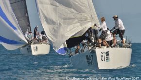
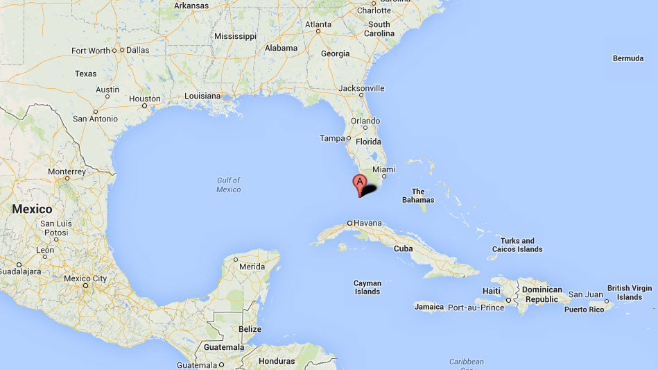
Quantum Key West 2014 is gearing up for its trademark full week of racing on the aqua-colored waters off the coast of the Conch Republic in Key West, FL. Located at the southernmost tip of the continental United States, and just 90 miles from Cuba, having a handle on the weather is a challenge and a key to success at this elite event. Here is the weather forecast prepared by Sailing Weather Service issued 0730 LT 19 January 2014:
WARNINGS AND ADVISORIES: There are no active warnings or advisories posted for the sailing area today. Conditions can change quickly. Please monitor NOAA All Hazards Radio on your VHF for the latest official warnings and advisories from The National Weather Service.
OVERVIEW: A range of wind conditions from light to fresh are expected during Race Week, as a progressive weather pattern brings a return of Arctic air to the eastern half of the US.
The regatta is expected to start on a light note, with high pressure and weak gradients expected on Monday. Some variable/unstable winds are very possible. Conditions will start to change on Tuesday as a strong cold front approaches from the north. While the frontal passage is expected to hold north of Key West until later Tuesday night or early Wednesday morning, some building W then NW winds are forecast “leak†across the front and arrive for unsteady but more moderate breezes for Tuesday’s racing. There may also be some showers about Tuesday in advance of the approaching front.

Strongest winds of the week are forecast on Wednesday. A cold front will move through by early Wednesday morning, bringing a building NW/N pressure gradient as cool air spreads south across the eastern Gulf. Fresh to strong winds are likely on Wednesday, especially in the morning, with some moderation/easing possible in the afternoon.
High pressure moving north of FL will bring a moderating and veering wind Thursday. NE winds on Thursday are forecast to ease. On Friday, the high pressure north of FL gets reinforced and this could back winds NNE/NE once again and also bring a bit more pressure to the sailing area.
***************************************************************
OUTLOOK FOR MONDAY (20 January 2014)
The remains of a low pressure trough are expected to pass across the southern FL peninsula in the morning. At the same time, a weakening high pressure center will be over the Gulf waters north and west of Key West. Further afield, a strong cold front will be moving southeast out of the Central US and into the Gulf coastal states northwest of FL by later in the day.
Some NW winds in the morning thanks to the remains of the trough. But these will likely ease and back left through the morning and early afternoon. Some very light gradients are expected as the high pressure weakens/dissipates with time, tending SW in the afternoon as a pre-frontal gradient starts to influence the area.
Detailed Wind Forecast:
Time Wind Speed Wind Direction (MAG)
(LT) Mean Range Mean Range
0800 09 06-12 290 270-310
1000 05 03-07 Variable …dying and backing
1200 04 02-06 Variable
1400 07 05-09 To 260
1600 08 06-11 250 225-265
1800 09 07-12 255 230-265
SEAS: A slight swell main 1 ft or less.
TEMPERATURE RANGE: Upper 50SF / Low 70sF
WEATHER: Mainly sunny conditions are forecast. There will be some cumulus likely developing over the Keys, but with light winds aloft these are expected to move little or perhaps drift slowly toward the southeast. Some increase in high cloud is possible during the afternoon, with little consequence on the winds expected.
***************************************************************
OUTLOOK FOR TUESDAY (21 January 2014)
Weakening high pressure moves west then southwest of Key West and dissipates. A cold front will move out of the southern Mississippi River valley and into the northern Gulf later tomorrow morning. The front will move south to lie off Tampa and possibly Fort Myers by tomorrow evening.
Very light winds are expected at first under the influence of the dying high pressure. Then, a pre-frontal gradient will start to slowly build through the day, with mainly WSW/W winds expected. There is a chance of some right-shifted momentum “leaking†toward Key West later in the day, however the abrupt right shift and build of the front will almost certainly hold off until later tomorrow night/early Wednesday morning.
Increasing moisture ahead of the front is expected to lead to more cloud and an increased risk of rain showers through the day. The chance of rain occurring in the sailing area at some point during the racing day is about 50%.
Detailed Wind Forecast:
Time Wind Speed Wind Direction (MAG)
(LT) Mean Range Mean Range
0800 08 05-11 225 210-250
1000 05 03-08 230 215-250 …¦perhaps becoming very patchy
1200 06 04-08 250 235-265 …larrge holes possible
1400 10 08-12 265 250-280 …watch for posssible right shift and build
1600 12 10-14 275 260-290
1800 13 11-15 290 275-310
SEAS: Slight becoming moderate chop 1-3 ft in the afternoon.
TEMPERATURE RANGE: Near 60F / Low 70sF
WEATHER: Increasing clouds with a chance of showers develop late morning. The risk of showers will increase with time through the afternoon.
***************************************************************
OUTLOOK FOR WEDNESDAY (22 January 2014)
A cold front will move through in the early morning, bringing and abrupt increase in winds and some very gusty conditions. Winds will be strongest in the morning, then a slow veering and easing trend in the post-frontal gradient is forecast to moderate winds and seas in the afternoon.
WIND: NNW in the morning, building 20-25 kts for a time mid-morning. A gradual easing and veering NNW/N is expected from later morning through the afternoon 15-20 kts.
SEAS: Very rough 3-6 ft. Roughest further offshore near the bottom of the courses. Seas subsiding somewhat through the afternoon.
TEMPERATURE RANGE: Near 60F / Mid-60sF
WEATHER: Some broken cloud cover and a slight chance of showers in the early morning. Then clearing to partly cloudy conditions in the morning.
***************************************************************
OUTLOOK FOR THURSDAY (23 January 2014)
Weakening high pressure moves across FL, with moderating winds and seas veering NE/E with time. A late backing to NE or NNE is possible.
WIND: NE/ENE 8-13 in the morning, possible 11-15 for a time. Then backing NNE/NE mid-/late-afternoon 13-18 kts.
SEAS: 2-3 ft.
TEMPERATURE RANGE: Near 60F / Low-70sF
WEATHER: Mainly sunny. Some cumulus cloud offshore over the Gulf Stream in the AM. Cumulus develop on the upper keys in the afternoon and may drift offshore toward the course areas PM.
***************************************************************
OUTLOOK FOR FRIDAY (24 January 2014).
Another Arctic High pressure plunging into the deep south will reinforce the N/NE gradient, with stronger winds likely at least in the morning. The gradient will veer in the afternoon and an easing trend is forecast.
WIND: N/NE building 15-20 knots through late morning, then tending NNE/NE and easing 12-17 kts in the afternoon. Possibly lighter by later afternoon.
SEAS: Very rough 3-5 ft in the morning, moderating 2-4 ft in the afternoon.
TEMPERATURE RANGE: Near 60F / Low-/Mid-70SF
WEATHER: Some scattered to broken cloud in the morning with a slight chance of showers. Then becoming mostly sunny.

Related Posts

Six hours with Ken Legler →

Pics or it didn’t happen →

Drunk man steals tiki hut bar →