A New Spin on Waterspout Forecasting
Published on August 20th, 2015
by Mark A. Thornton, LakeErieWX
Several waterspouts, the intense columnar vortices considered “tornadoes over water”, have been reported across the Great Lakes over the past two weeks. Waterspouts come in two varieties – tornadic and fair weather—with the fundamental difference between them being the type of storm they are associated with, and the manner in which they form.
Tornadic waterspouts are produced by supercell thunderstorms. They form when the relatively long-lived, mid-level rotation within the storm extends down to the surface of the water. Tornadic waterspouts may be long-lived and cyclic, a result of the self-sustaining nature of supercell thunderstorms. Fortunately, only 5% of all thunderstorms are supercells, therefore tornadic waterspouts occur infrequently across the Great Lakes.
Great Lake’s boaters are much more likely to encounter fair weather waterspouts. Fair weather waterspouts form from the surface of the water upward, in association with the updraft of a rapidly growing cumuliform cloud. Although far less powerful than their tornadic cousins, winds associated with fair weather waterspouts are capable of reaching sixty knots or more, and have a long history of capsizing small boats, shredding sails and damaging equipment.
Don’t let their rather benign name fool you, fair weather waterspouts should always be avoided. An understanding of their formation and behavior, and the use of a recently developed forecast graphic, can help you steer clear. Let’s look at fair weather waterspouts in more detail.
Fair-Weather Waterspout Environments And Formation
Fair weather waterspouts harness the energy associated with the temperature difference between the warm water of the lake and relatively cold air several thousand feet aloft. When analyzing the potential for waterspout development, meteorologists compare the lake surface temperature to the air temperature at a height of approximately five-thousand feet. A temperature difference of 13°C (23.4°F) or greater indicates that the atmosphere is supportive of the rapidly developing updrafts required for the formation of a fair weather waterspout
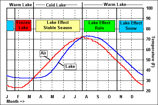
Large temperature differences between the surface of the lake and the air five thousand feet above it are relatively easy to achieve during late summer and fall. As the chart of average monthly water and air temperatures shows, the Great Lakes typically reach their maximum temperature in August, approximately one month later than the peak air temperature is reached (Figure 2). As summer gives way to fall, transient weather systems promote the arrival of much cooler air from the north, setting the stage for a dramatic increase in waterspouts from late July through October (click here for graphic).
However, temperature difference isn’t the only ingredient needed to produce a favorable environment for waterspout formation. Because the vortex forms from the surface upward to the cloud base, a pre-existing source of low-level rotation (vorticity) must be available. This rotation is predominantly counter-clockwise, and can be found along surface boundaries such as cold, warm, or stationary fronts. On the Great Lakes, waterspouts frequently tap the rotation associated with land breeze boundaries (click here for graphic) which typically form during the late evening and persist until early- or mid-morning.
Meteorologists use the term convergence to describe the opposing flow of wind along a surface boundary (click here for diagram). Convergence along a boundary tends to promote the upward motion of air which, if the atmospheric dynamics are supportive, leads to cloud development and perhaps a thunderstorm. The combination of low-level convergence and upward motion feeding the cloud act to stretch the updraft vertically (click here for animation from Penn State University), causing the pre-existing, low-level spin to increase, and voila — a waterspout forms.
Fair weather waterspouts may also form when the updraft associated with a pre-existing cumulus congestus cloud (click here for image) – fueled by the temperature difference discussed above – encounters a surface boundary, lifts and stretches the pre-existing low-level rotation up to its base.
A fledgling fair weather waterspout is relatively fragile and easily disrupted by too much wind, variations in wind direction with height, or an encounter with cold air near the surface. Waterspouts rarely form when winds between the surface and 5,000 feet are greater than 35 knots. It is also beneficial if the direction of the wind in the lowest few thousand feet is reasonably uniform, or in technical terms, when directional wind shear is weak. Relatively fast winds or strong wind shear inhibit the strength and continuity of the storm’s updraft, and suppress the formation of the waterspout’s small-scale vortex. In addition, because rain-cooled air would quickly undercut the developing updraft, waterspouts typically form before the storm produces any precipitation.
Forecasting Waterspouts
Until fairly recently, forecasting waterspouts was a tedious and time-consuming task. Meteorologists gathered and reviewed a variety of forecast graphics to determine if, where, and when the various waterspout ingredients might occur simultaneously.
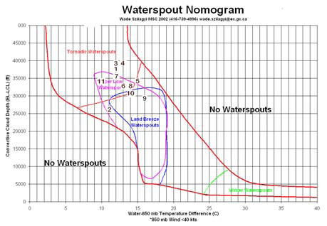
Ten years ago, Canadian meteorologist Wade “Waterspout” Szilagyi developed the waterspout nomogram as a visual tool to help identify when conditions might be supportive of waterspouts (figure 3). Although a step in the right direction, the nomogram still required forecasters to review every single waterspout ingredient for each forecast period.
Determined to develop a more efficient and integrated method of forecasting waterspouts, Szilagyi collected data on 263 waterspout outbreaks from 1988 to 1999. This dataset was used to test the forecasting efficacy of several atmospheric parameters related to waterspout formation. The result was the Szilagyi Waterspout Index (SWI), introduced as a forecasting resource in 2009. SWI values range from -10 to +10, with values greater than 0 suggesting waterspouts are likely.
Experimental graphics featuring SWI values across the Great Lakes basin are now available online. With the possible exception of converting Greenwich Mean Time to local time (subtract 4 hours in the Eastern Time zone and 5 hours in the Central Time Zone) using the graphics is relatively straightforward.
In the examples above, the SWI forecasts for 2:00 am EDT (figure 5) and 8:00 am EDT (figure 6) indicate the potential for waterspouts was isolated to Lake Erie, Lake Ontario, and a small region of Georgian Bay. The colors on the graphics indicate the values of SWI, with the brightest colors representing the highest values (the legend is located in the upper-left corner of each graphic). A closer review of the two forecasts shows the risk for waterspouts was greatest along the southern portions of Lake Erie and Ontario (yellow and red shading). In addition, the increase in SWI values from 2:00 am EDT and 8:00 EDT (figure 6) indicate that the potential for waterspout development was expected to increase during the time period. The SWI forecasts are short-range products that are available online at the International Centre for Waterspout Research (ICWR) (click here).
Cooler temperatures and more reliable winds make fall a perfect time to enjoy the Great Lakes, and checking the SWI forecasts before heading out can help ensure a smooth voyage.


