Dorian’s Destructive Impacts
Published on September 3rd, 2019
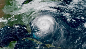
(September 3, 2019) – Hurricane Dorian has finally begun its long-awaited march up the Southeast coast, prompting hurricane and storm surge warnings from Florida’s east coast to eastern North Carolina.
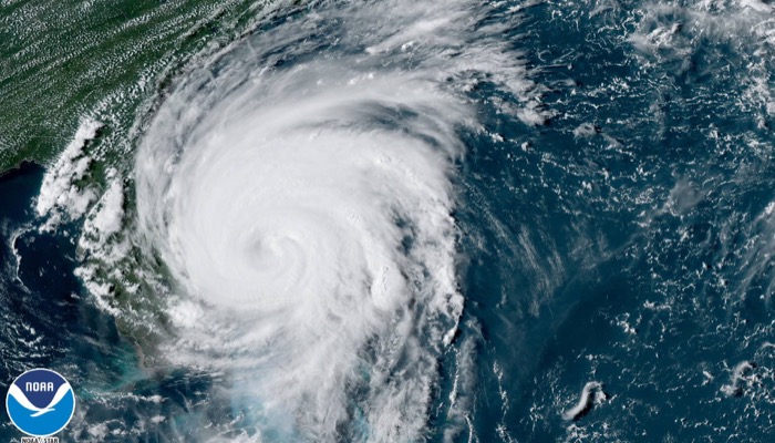
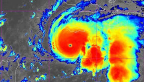
Dorian’s wind intensity has backed off from its peak, currently a Category 2 hurricane. Regardless of its intensity and track, Dorian will have a significant, damaging impact from Florida’s Atlantic coast to parts of Georgia, South Carolina, North Carolina and possibly southeastern Virginia this week.
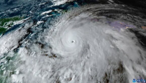
Dorian’s eyewall finally moved away from Grand Bahama Island today after pummeling the island since Sunday (September 1) night with destructive winds and catastrophic storm-surge flooding. Settlement Point, Grand Bahama, reported a sustained wind of 61 mph with a gust to 82 mph last evening.
This intense hurricane lashed the northwestern Bahamas for more than 48 hours since first beginning its siege on the Abacos Islands two days ago.

Dorian’s wind field has grown, despite its somewhat lower winds. Tropical-storm-force winds (39-plus mph) now extend up to 175 miles from the eye, while hurricane-force winds (74-plus mph) extend up to 60 miles from the eye.
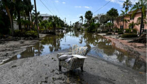
Dorian is already having destructive impacts on the Florida coast. Major beach erosion already occurred at Flagler Beach, according to the National Weather Service.
Squalls from the outer periphery of Dorian continue to wrap into parts of the Florida Peninsula. Sustained tropical-storm-force winds arrived at Juno Beach, Florida, Monday afternoon and have continued into Tuesday, with gusts topping 60 mph at times.
These outer rainbands will also be capable of spawning isolated tornadoes along the immediate east coast of Florida through tomorrow. This threat will shift to the immediate coasts of Georgia and the Carolinas Wednesday later this week.
A hurricane warning is in effect in Florida from Sebastian Inlet to Ponte Vedra Beach, including Melbourne and Daytona Beach, Florida. A hurricane warning has also been posted for the entire South Carolina coast and northward to Surf City, North Carolina. This watch includes Charleston, South Carolina, and Wilmington, North Carolina.
Hurricane warnings mean that hurricane-force winds (74-plus mph) are either already occurring or expected somewhere within the warning area, generally within 36 hours. Preparations to protect life and property should be rushed to completion.
A storm surge warning has also been issued from Jupiter Inlet, Florida, to Surf City, North Carolina. This warning includes Daytona Beach, Florida; Jacksonville Beach, Florida; St. Simons Island, Georgia; Tybee Island, Georgia; Charleston, South Carolina; and Wilmington, North Carolina.
Storm surge warnings mean there is a danger of life-threatening inundation, from rising water moving inland from the coastline, within the warning area during the next 36 hours. If you live in an area prone to storm surge, be sure to follow the advice of local officials if evacuations are ordered.
A hurricane watch has been posted along the southeastern U.S. coast from north of Ponte Vedra Beach, Florida, to the Savannah River at the border between Georgia and South Carolina, from north of Surf City, North Carolina, to the North Carolina/Virginia border and for Albemarle and Pamlico sounds in North Carolina. This watch includes Savannah, Georgia, and the Outer Banks of North Carolina.
Hurricane watches are issued when hurricane-force winds are possible within the watch area. They are posted 48 hours before the first tropical-storm-force winds (39-plus mph) are expected.
A storm surge watch has also been posted in North Carolina from north of Surf City to Duck, for Albemarle and Pamlico sounds and the Neuse and Pamlico rivers. This watch includes parts of the Outer Banks. A storm surge watch means that a life-threatening inundation is possible within the watch area during the next 48 hours.
A tropical storm warning has been posted from north of Ponte Vedra Beach, Florida, to the Savannah River at the border between Georgia and South Carolina, and from Jupiter Inlet, Florida, to Sebastian Inlet, Florida, meaning tropical-storm-force winds are expected within 36 hours. This warning also extends inland, including the Jacksonville and Orlando metro areas.
A tropical storm warning is also now in effect for Grand Bahama and the Abacos Islands in the northwestern Bahamas, including Freeport, Grand Bahama.
A tropical storm watch has been issued from the North Carolina/Virginia border to Chincoteague, Virginia, and for the Chesapeake Bay from Smith Point southward.
A watch is issued when tropical storm or hurricane conditions are possible within 48 hours. A warning is issued when those conditions are expected within 36 hours.)
Below is the latest on Dorian’s timing and what we know about potential forecast impacts right now.
Dorian’s Forecast Timing
Into tonight:
Dorian will still be impacting the northwestern Bahamas, but conditions should slowly improve as Dorian finally trudges northward. Bands of rain and strong winds will affect parts of Florida. Hurricane-force winds (74-plus mph) are expected in the hurricane warning area of eastern Florida overnight. Coastal flooding will spread northward along the Florida, Georgia and South Carolina coasts.
Tomorrow:
Dorian is expected to move northward, then northeastward near the coasts of northeastern Florida, Georgia and southern South Carolina. Storm-surge flooding, beach erosion and damaging winds are all possible in these areas, particularly in areas covered by storm surge and hurricane warnings. Rainfall flooding is also a threat.
Through the rest of the week, into the weekend:
Dorian is expected to pass near the coasts of northeastern South Carolina and North Carolina. A landfall is possible anywhere in this zone, which would bring the most damaging winds and storm-surge flooding.
However, these impacts will also occur even if Dorian’s center does not make a landfall. Heavy rain will also lead to flooding in this area. Some impacts from wind, coastal flooding and rainfall flooding could spread as far north as the Virginia Tidewater and the southern Delmarva Peninsula late Thursday.
Dorian is then expected to race off the Northeast Seaboard but could track close enough to bring rain and some wind to the Virginia Tidewater, Delmarva Peninsula, Jersey Shore, Long Island, Nantucket, Martha’s Vineyard and Cape Cod before it heads toward the Canadian Maritimes by this weekend.
Dorian’s forecast track continues to be the razor’s edge between more severe hurricane impacts reaching land, compared to those impacts staying barely offshore. The reason for this is the upper-level high-pressure system that had been steering Dorian westward fizzled, stalling Dorian temporarily in an environment without a steering wheel.
Over the next day or so, a gap between upper-level highs east of Dorian and over the southern Plains of the United States will allow Dorian to turn northward. Late in the week, a southward dip in the jet stream approaching from the Great Lakes should grab Dorian and accelerate it toward the Canadian Maritimes.
Dorian will be pulled northward along the Southeast coast between two areas of high pressure. Exactly when it makes those north and northeastward turns is critical. If those turns occur later, it’s more of a landfall danger – or at least an eyewall strike – for parts of the Southeast coast. If it makes those turns sooner, the threat of a landfall is less, particularly in Florida and Georgia.
Regardless of its exact track and any possible changes in intensity, Dorian will be a dangerous hurricane with significant impacts along the Southeast coast. As was seen with Hurricane Matthew in 2016, a hurricane doesn’t have to make landfall in an area to produce destructive impacts. Residents should have their hurricane plans ready to go and follow the directions of local emergency management.
Dorian’s Storm Surge, Wind and Rain Impacts
Larger swells and battering waves generated by Dorian will spread northward and increase along the Southeast coast from eastern Florida to North Carolina and will persist for several days.
This will lead to increasing beach erosion and coastal flooding, particularly around times of high tides, which are generally an hour or so before or after midday and midnight.
These impacts will occur regardless of how close Dorian’s center tracks or whether it ever moves ashore in any part of Florida, Georgia or the Carolinas. The National Hurricane Center says water could reach the following heights above ground level if the peak surge coincides with high tide.
-Savannah River (at the border between Georgia and South Carolina) to Cape Lookout, North Carolina: 4 to 7 feet
-Volusia/Brevard County line in Florida to the Savannah River: 3 to 5 feet
-Cape Lookout, North Carolina, to Duck, North Carolina, including Pamlico and Albemarle sounds and the Neuse and Pamlico rivers: 3 to 5 feet
-Jupiter Inlet, Florida, to the Volusia/Brevard County line in Florida: 2 to 4 feet
That said, this storm-surge forecast will likely change depending on how close Dorian tracks to Florida and other parts of the Southeast coast.
The worst wind impacts will occur within the hurricane’s eyewall, assuming any part of it affects land, which is still uncertain. Tropical-storm-force winds (39-plus mph) will arrive along the coast well ahead of Dorian’s closest pass, making preparations difficult.
These winds will be capable of taking down trees and power lines across the Southeast, leading to power outages that could last for several days. Ground soaked by rain will only increase this threat, allowing trees to topple in winds less strong than typically expected.
Power outages are most likely along the immediate coastline from Florida to North Carolina, where winds will be stronger than areas farther inland. However, outages are still possible from eastern Florida to southeastern Virginia inland from the coast.
Here are the latest rainfall projections from the National Hurricane Center and NOAA’s Weather Prediction Center:
-Coastal South Carolina and North Carolina: 5 to 10 inches, locally up to 15 inches.
-Near the coast from eastern Florida through eastern Georgia: 3 to 6 inches
-Southeastern Virginia: 3 to 6 inches
Should the storm track farther offshore, these rain amounts will be less. And if the track is more inland, this rain footprint would also include areas farther inland. The entire Florida Peninsula and the Southeast coast as far north as southeastern Virginia need to be on alert this week.
Dorian became the first hurricane of Category 5 intensity to make landfall on Grand Bahama Island, after first making a pair of landfalls in the Abacos Islands of the northwestern Bahamas earlier.
Maximum sustained winds topped out at 185 mph two days ago, putting Dorian in a tie for the second-highest sustained wind speed among all Atlantic hurricanes. It also tied the 1935 Labor Day Hurricane in the Florida Keys as the strongest landfalling hurricane in the Atlantic Basin.
According to Robert Rohde, lead scientist at Berkeley Earth, while over the northwestern Bahamas, Dorian was also the slowest-moving major hurricane (Category 3 or stronger) on record in the Atlantic Basin, crawling at just 1 to 2 mph averaged over a 24-hour period.
Source: weather.com

Related Posts
Good news for Atlantic hurricane season →
Three places overdue for hurricane →
Limitations of the Saffir-Simpson scale →