New record for Atlantic hurricane season
Published on June 15th, 2020
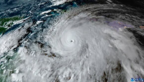
The 2020 Atlantic hurricane season is already one for the record books and it’s only just getting started. With an early jump-start to the season, a record number of named storms, and a storm reaching states that don’t normally see tropical systems, this season is off to a fast and interesting start.
Record three named storms
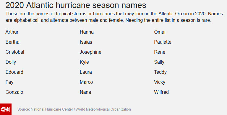
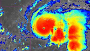
Before the season officially began on June 1, we already had two named storms: Arthur and Bertha, which is impressive in and of itself. Then we added Cristobal, the third named storm of the season, and that pushed us into the record books.
“We did set a record for the earliest third named storm formation date on record, breaking the old record set in 2016,” says Phil Klotzbach, a research scientist at Colorado State University.
This means that this year was the earliest a named storm that starts with the letter “C” has formed.

Even more impressive: All three of those storms had a direct impact on the US. The latter two made a direct landfall on US soil; Bertha in South Carolina, and Cristobal in Louisiana.
“Historically, the odds of any named storm making US landfall is about 1 in 4, so the odds of two consecutive named storms making landfall is 1 in 16,” Klotzbach says. “Of course, the storms we’ve seen so far are typical for early season storm activity. Generally, they’ve been short-lived and fairly weak.”
For many meteorologists, this doesn’t come as a surprise since forecasts were calling for a very active season.
“We knew this hurricane season was shaping up to be a busy one, with every seasonal hurricane forecast group calling for above-average activity, and we did not have to wait long for things to get rolling,” says Brandon Miller, CNN meteorologist.
If you blinked, you likely missed Bertha
Bertha was a sneaky storm that formed only one hour before making landfall in South Carolina. At 9:30 a.m. on May 27, Bertha made landfall just east of Charleston with maximum sustained winds of 50 mph.
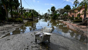
The bigger issue with Bertha was the flooding it caused for Florida while it was still just a tropical disturbance. Miami started off the month of May in a moderate drought level, but thanks in part to moisture from Bertha, the city ended the month with its wettest May on record. Unfortunately, because so much of this rain came in a short period of time, this triggered flooding throughout many streets.
Cristobal’s unusual travel route
When you think of states that are impacted by hurricanes and tropical storms a lot, Wisconsin isn’t one of them. However, the remnants of Cristobal moved into states like Iowa and Wisconsin, which rarely see tropical systems.
Prior to Cristobal, only three tropical systems have ultimately tracked across Wisconsin since records began: Hurricane Gilbert in 1988, an unnamed hurricane in 1949, and the infamous Galveston Hurricane in 1900.
What about the rest of the season?
“Normally, early in the season we see weak tropical disturbances struggle to ‘get over the hump’ and become named tropical storms,” Miller points out. “But this year each one seemingly has formed into a named system — will that portend a continuing trend right through the peak of the season? We will have to wait and see but, historically speaking, early activity does not necessarily correlate with an active peak season.”
A lot of things need to be taken into account when forecasting for an entire hurricane season: sea surface temperatures, El Nino/La Nina presence, and any other climatological trends.
“Given that we’re expecting an active season, I would assume we’ll see more landfalls this year,” Klotzbach adds. “Of course the big question is… will any of these be significant hurricanes?”
Klotzbach noted that historically major hurricanes are more likely to form off the west coast of Africa, extending west into the Caribbean.
It’s also important to note some of the more active hurricane seasons did not start early. The most active Atlantic hurricane season on record, 2005, did not have any preseason named storms. The same goes for 2010 and 2011, also quite active seasons,.
Colorado State University just increased its tropical seasonal forecast slightly on June 4. A major contributing factor to that is that large-scale conditions are becoming slightly more favorable.
Colorado State is now calling for 16 named storms, nine hurricanes, and four major hurricanes (Category 3 or higher). NOAA is still calling for 13 to 19 named storms, six to 10 hurricanes, and three to six major hurricanes. For reference, an average season is 12 named storms, six hurricanes, and three major hurricanes.
“Right now, it’s looking fairly juicy across most of the North Atlantic, and you can see considerable anomalous warmth in the eastern Atlantic,” Klotzbach says. “Historically, this is the area that has correlated best with active Atlantic hurricane seasons.”
Source: www.cnn.com

Related Posts
Good news for Atlantic hurricane season →
Three places overdue for hurricane →
Limitations of the Saffir-Simpson scale →