
Getting help to map the mess
Published on July 19th, 2025
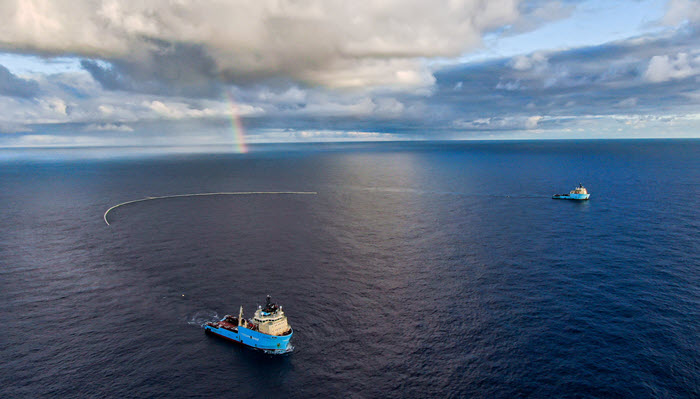
The Great Pacific Garbage Patch (GPGP) is estimated to have 100,000 tons of plastic in the North Pacific Ocean, but despite it covering an area twice the size of Texas, its exact location can be hard to pinpoint. In their mission to shrink the patch, a Dutch non-profit is getting help from Transpac Race competitors to map the mess.
For those boats not returning to the mainland on a Pasha roll-on/roll-off ship, many have volunteered to be fitted with AI cameras to detect plastic in the world’s largest accumulation of floating plastic. They will also be given GPS drifter buoys to deploy at specific locations to tag discarded nets and other abandoned gear.
“The GPGP is an ever-moving plastic soup that impedes the ocean’s ability to help regulate the climate and is harmful to marine life,” explained Dr. Peter Puskic, Senior Field Scientist at The Ocean Cleanup. “Technology has a big part to play in the future ocean cleanup and we’re grateful that the Transpac sailors have volunteered to help improve scientific understanding of the scale and positioning of the plastic.”
The AI cameras are called Automatic Debris Imaging Systems (ADIS) which monitor and map the distribution of plastic debris. They will take photos of plastics afloat at sea and transmit the data to enable the organization to map plastic hotspot concentrations and use predictive software to track their movement using ocean circulation, wave, and wind data.

The GPS tracking buoys will be used to tag lost, or abandoned, fishing gear and ghost nets. This will also help track and model where these large items are floating and pinpoint them for smart, targeted, future cleanup efforts.

Related Posts
Will North America care about 2027 race? →

Sailing legend targeted by trans activists →
Racing with no AAA on speed dial →
 We’ll keep your information safe.