
Boaters will not be left adrift as NOAA privatizes printing of nautical charts
Published on November 12th, 2013
A note from Coast Survey…
Headline writers are in their glory! Creative wordplay makes great copy, and we appreciate all the attention garnered by our October 21 announcement about the end of lithographic nautical charts. We need to take a moment, however, to point out an important fact: the public will still be able to purchase official NOAA paper nautical charts, even after the government stops printing them.
“NOAA tosses sailors in digital seas.” “Stop the presses: no more nautical charts.” “Agency goes off the map.” “Paper charts go the way of sextant in digital age.” Headline writers around the world are using their best stuff. Fortunately, the hundreds of articles resulting from our press release, NOAA Announces End of Traditional Paper Nautical Charts, are mostly correct. Unfortunately, some miss the announcement’s very first line: NOAA-certified Print-on-Demand partners will continue to sell up-to-date paper nautical charts.
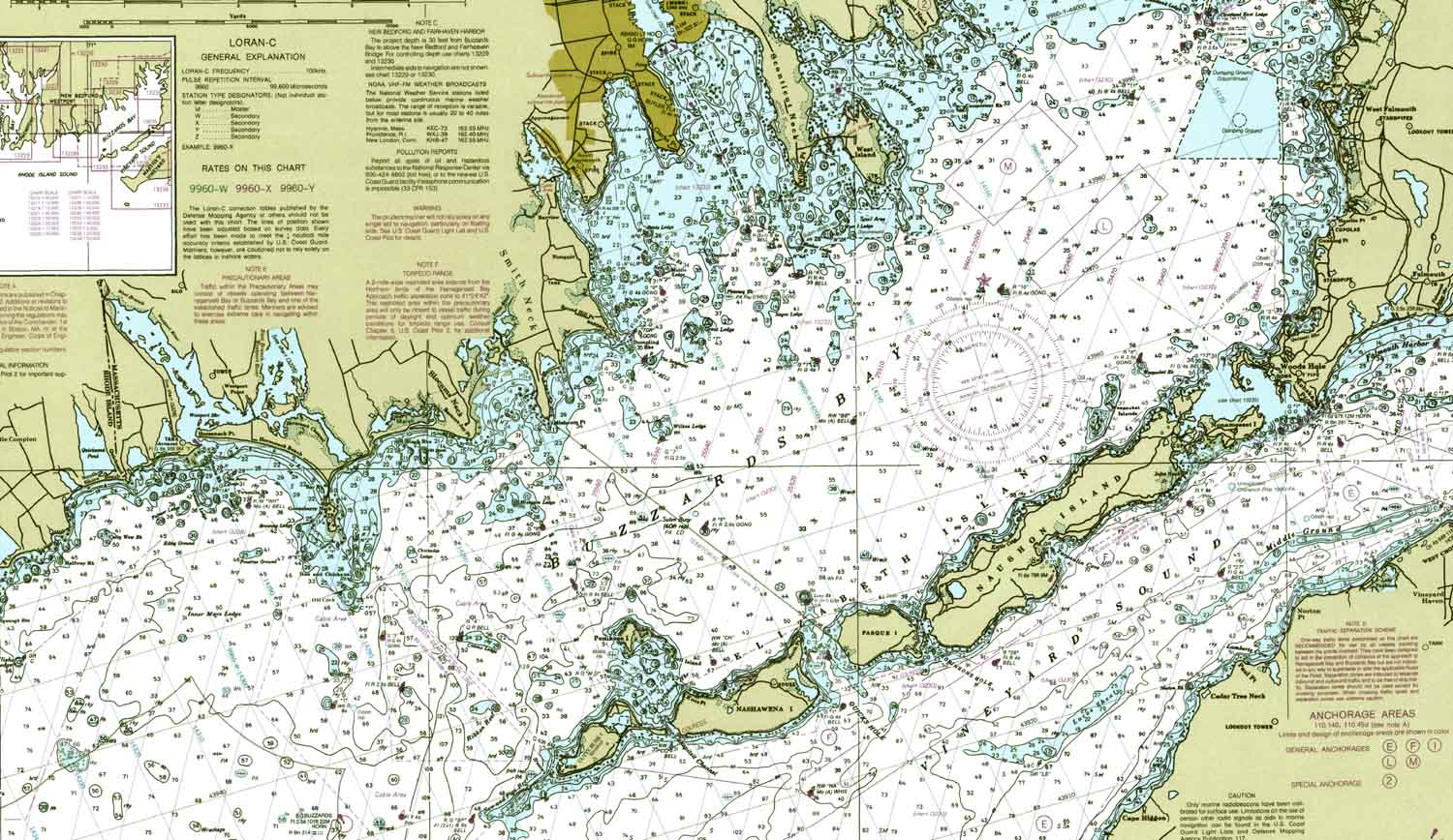
Let’s summarize again, for those who may have missed the original announcement. On April 13, 2014, the federal government will stop lithographic printing of NOAA’s nautical charts. It is the end of the 150-year heritage of a traditional printing process. It is not the end of paper nautical charts, however, as Coast Survey will continue to update our Print-on-Demand (POD) paper nautical charts weekly, to add all of the latest critical chart corrections. The public can purchase paper POD nautical charts at their convenience. Professional mariners can use the POD charts to meet their chart carriage requirements.

Additionally, Coast Survey is offering almost all of NOAA’s thousand nautical charts as PDF nautical charts, for free download. The site got over a million hits in the first seven days after we announced their availability.
While the PDF nautical charts are immensely popular, we expect that serious mariners will opt for professionally printed and time-certified POD charts that meet chart carriage requirements. There are currently two NOAA-certified POD providers (OceanGrafix and East View Geospatial) and, in the last couple of weeks, we’ve had a dozen more companies indicate their interest in becoming a POD provider. With government printing of lithographic charts continuing until mid-April, we have ample time to bring the printing privatization program to a higher level. (Here is the FedBizOpp that has been available since 2008. We expect to announce a new FedBizOpp soon.)
Coast Survey’s decision to privatize printing and sales of paper nautical charts, while continuing to maintain and update the suite of over a thousand NOAA charts, was made after a decade of experience with print-on-demand technology and service. Beginning in 1999, private companies have been able to become NOAA-certified POD chart providers, and there has been a measurable uptick in interest as Coast Survey undertakes greater privatization efforts. Entrepreneurs understand that sales growth is promising, since most non-government customers have switched to POD for printed charts. We expect to see increasing product differentiation, with optional value-added features, in the coming months.
So, to summarize, even though the government will stop printing lithographic nautical charts, the public can still purchase and use NOAA-certified paper charts. Boaters will not be up a creek without a paddle… or without a chart.
For more information, see our Frequently Asked Questions.
NOAA Office of Coast Survey is the nation’s nautical chartmaker. Originally formed by President Thomas Jefferson in 1807, Coast Survey updates charts, surveys the coastal seafloor, responds to maritime emergencies, and searches for underwater obstructions that pose a danger to navigation.
November 12, 2013

Related Posts

Can’t make this stuff up →
Striking contrasts for 2025 storm season →
Tracking abandoned boats across USA →
 We’ll keep your information safe.