
Dorian lashing the Southeast US coast
Published on September 5th, 2019
(September 5, 2019) – Hurricane Dorian is lashing the Carolinas with storm surge flooding, rainfall flooding, high winds and tornadoes and will have impacts in southeast Virginia and southeast Massachusetts tomorrow and into the weekend.
Dorian’s maximum sustained winds have ticked down slightly, making it a Category 2 hurricane. Regardless of these small intensity changes, the hurricane’s impacts will likely be similar. Hurricane-force winds are now coming ashore in South Carolina with damage has been reported more than 50 miles inland from tropical-storm-force winds.
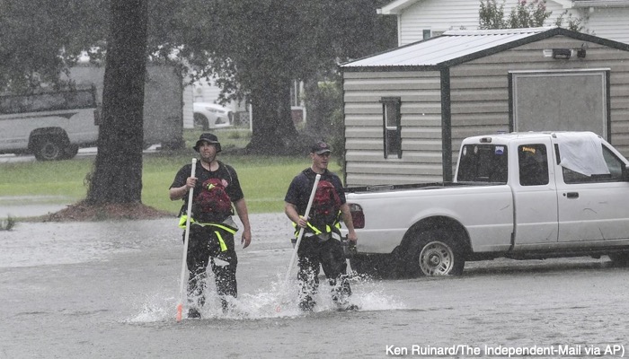
Storm surge is now causing flooding in the Carolinas, including knee-deep water at the Inlet Square Mall in Garden City, North Carolina and rushing water on streets in Debordieu, South Carolina.
The eyewall containing the strongest winds in Dorian is very close to the South Carolina coast. A station at Winyah Bay, South Carolina, reported sustained winds of 77 mph and a wind gust of 88 mph, earlier this afternoon.

Given Dorian’s continued movement, areas just up the coast from Myrtle Beach, South Carolina, could experience the hurricane’s most intense winds in this ring of convection closest to the center.
Tornado watches are in effect for parts of northern South Carolina and eastern North Carolina through early evening. There have been over a dozen reports of tornadoes in the Carolinas Thursday, some of which have been damaging. A waterspout moved ashore in Emerald Isle, North Carolina, damaging homes in an RV Park.
Homes were damaged near Carolina Shores, North Carolina, from another apparent tornado, and law enforcement sighted a tornado in North Myrtle Beach, South Carolina, where condos and a trailer park were damaged.
Tornadoes were also sighted in Little River, South Carolina, and northeast of Wilmington, North Carolina. Isolated tornadoes are common mainly in outer rainbands when tropical storms and hurricanes affect land.
The combination of rainfall flooding plus flooding from storm surge prompted the closing of over 50 streets in Charleston, South Carolina, this morning, according to local emergency management. Surge flooding was much lower than forecast, due to winds still blowing offshore as the center of Dorian remained just far enough to the east and offshore of Charleston.
However, heavier rainbands continue to wrap in around Dorian. According to the National Weather Service, 3 to 7 inches of rain had already fallen in the Charleston metro area, with more on the way. Tropical-storm-force winds (39-plus mph) extend up to 220 miles from the center, while hurricane-force winds (74-plus mph) extend up to 60 miles from the center.
Dorian’s Forecast Timing
Today: The center of Dorian will pass near the South Carolina coast. The eyewall is likely to scrape along the upper South Carolina coast during the late afternoon hours, bringing strong winds and storm surge flooding. These impacts will also occur even if Dorian’s center does not make a landfall. Heavy rain will also lead to flooding in this area. Coastal flooding, wind and rainfall flooding will worsen and spread from south to north in eastern North Carolina, then into the Virginia Tidewater and the southern Delmarva Peninsula Thursday night.
Tomorrow: Dorian’s center will track near, if not make a landfall over, eastern North Carolina, bringing storm-surge flooding, damaging winds and flooding rain as far north as southeastern Virginia. By Friday night, the center of Dorian will move into the Atlantic Ocean, with improving conditions in North Carolina and southeastern Virginia.
Into the weekend: Dorian may track close enough to bring a period of rain and some tropical storm-force winds to southeastern New England before it quickly races toward parts of Nova Scotia and Newfoundland later Saturday into Sunday.
Dorian will be a dangerous hurricane with significant impacts along the Southeast coast, with a track similar to Matthew in 2016, a $10-billion hurricane disaster. Larger swells and battering waves generated by Dorian will spread northward and increase along the East Coast from the Carolinas to New England.
The worst wind impacts will occur within the hurricane’s eyewall, which may scrape parts of the coast of the Carolinas, even if Dorian’s center never makes a landfall. Tropical-storm-force winds (39-plus mph) will arrive along the coast well ahead of Dorian’s closest pass, making preparations difficult.
These winds will be capable of taking down trees and power lines across the Southeast coast, leading to power outages that could last for several days. Ground soaked by rain or storm surge flooding will only increase this threat, allowing trees to topple in winds less strong than would typically be expected to produce damage.
Power outages are most likely along the immediate coast from South Carolina to North Carolina, where winds will be stronger than areas farther inland. However, outages are still possible from central South Carolina to the southern Delmarva Peninsula.
Dorian was upgraded to Category 5 status on September 1 and became the first hurricane of that intensity to make landfall on Grand Bahama Island, after first making a pair of landfalls in the Abacos Islands of the northwestern Bahamas earlier in the day.
Maximum sustained winds topped out at 185 mph, tying the second-highest sustained wind speed among all Atlantic hurricanes. Dorian also tied the 1935 Labor Day Hurricane in the Florida Keys as the strongest landfalling hurricane in the Atlantic Basin.
According to Robert Rohde, lead scientist at Berkeley Earth, while over the northwestern Bahamas, Dorian was also the slowest-moving major hurricane (Category 3 or stronger) on record in the Atlantic Basin, crawling at just 1 to 2 mph averaged over a 24-hour period.
Dorian’s eyewall finally moved away from Grand Bahama Island on the afternoon of September 3 after pummeling the island for 41 straight hours with destructive winds and catastrophic storm-surge flooding.
In total, this intense hurricane’s eyewall lashed the northwestern Bahamas for an astonishing 51 straight hours since first beginning its siege on the Abacos Islands on the morning of September 1.
Sustained tropical-storm-force winds (39-plus mph) arrived at Juno Beach, Florida, on Labor Day and continued along parts of the northeastern Florida coast through September 4, with gusts topping 60 mph at times.
While Dorian’s most intense winds largely missed the Florida coast, there were destructive coastal impacts. Major beach erosion occurred at Flagler Beach, according to the National Weather Service. Major beach erosion was also reported in Vero Beach. Flooding of streets and parking lots was reported on barrier islands near Fort Pierce at high tide.

Related Posts
Is your name on the 2024 storm list? →

Are alarm bells beginning to go off? →
‘Extremely active’ 2024 hurricane season →

 We’ll keep your information safe.