Another above average storm season
Published on December 2nd, 2019
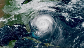
The 2019 Atlantic hurricane season officially wrapped up November 30, ending another above-average season that packed lethal power. Eighteen named storms formed during the season that started June 1, including six hurricanes and three major storms. An average season typically yields 12 named storms.
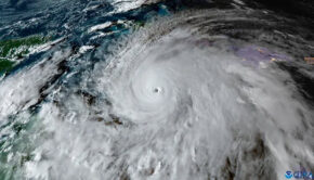
Dorian, a ferocious hurricane that stalled over the Bahamas in September, roared ashore with 185 mph winds, tying a record set by the historic 1935 Labor Day Storm. More than 60 people were killed, and nearly 300 remain missing.
Three named storms besides Dorian made landfall this year: Barry in Louisiana in July, Imelda in Texas in September, and Nestor in the Florida Panhandle in October.
The season was consistent with the National Oceanic and Atmospheric Administration’s forecast for another busy year, the fourth in a row. Forecasters warned that a strong monsoon season off Africa’s west coast, where many hurricanes form, would likely result in a high number of storms.

Warmer Atlantic waters and weak upper atmospheric winds that can tamp down hurricanes in the western Atlantic and Gulf of Mexico also cleared the way for storms to strengthen as they churned westward.
NOAA lead seasonal forecaster Gerry Bell said the potent seasons are part of an ongoing busy era that started in 1995, driven by the Atlantic Multidecadal Oscillation. The water circulation pattern helps determine long-range sea surface temperatures in the North Atlantic. It has been in a warm phase, feeding hurricanes that can grow more intense as they suck water vapor off warmer seas. The patterns generally last 25 to 40 years, he said.
“There’s no way to really predict how long it will last or when it will change over,” he said. “Hopefully it will soon, to help start to suppress hurricane activity, but there’s really no way to say at this point.”
Researchers believe warmer ocean temperatures driven by greenhouse gases warming the planet will help fuel more intense seasons. But because hurricane records are relatively short — only about 150 years — and tracking methods have evolved from ship reports to sophisticated satellite tracking, they are wary of attributing higher winds or more rain in any one storm to climate change.
However, research has increasingly drawn connections with modern storms, finding the number of storms that rapidly intensified between the 1980s and 2000s nearly tripled.
“If you look through the historical record, the main climate pattern causing these decade-to-decade changes in the Atlantic hurricanes is that Atlantic Multidecadal Oscillation,” said Bell, though he adds how much of that oscillation is influenced by climate change is hard to unravel.
“That certainly is an area that NOAA is involved in investigating and I know a lot of climate experts around the world are also examining,” he said.
Source: WUSF

Related Posts
Good news for Atlantic hurricane season →

Three places overdue for hurricane →
Limitations of the Saffir-Simpson scale →