El Niño could rival strongest on record
Published on August 13th, 2015
(August 13, 2015) – A new forecast from NOAA, the strongest forecast NOAA has issued so far this year, says this El Niño is “significant and strengthening,” with the potential to become very strong, even rivaling the strongest on record.
The National Weather Service’s Climate Prediction Center said Thursday that all computer models are now predicting a strong El Niño to peak in the late fall or early winter. A host of observations have led scientists to conclude that “collectively, these atmospheric and oceanic features reflect a significant and strengthening El Niño.”
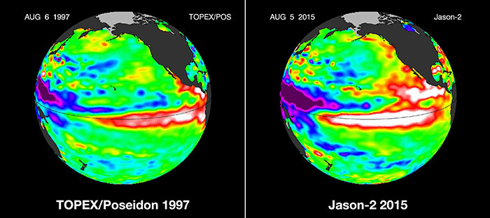
In order for El Niño to be classified as “very strong,” the temperature in the tropical Pacific Ocean needs to be running at least 2 degrees Celsius warmer than average for at least three months in a row. That can be a difficult hurdle to jump, and it’s only happened twice since meteorologists started to monitor conditions in the tropical Pacific: the winters of 1982-1983 and 1997-1998.
As of early August, this year is running neck and neck with the record 1997-1998 season, and NOAA forecasters are confident we will see an increase in tropical Pacific ocean temperature that would push this El Niño event into at least the “strong” category, potentially reaching or even exceeding the 2-degree “very strong” criteria.

NOAA forecasters say there is a 90 percent chance that El Niño will continue through the winter months, and an 85 percent chance (up from 80 in July) that it will last into early spring next year. Looking at the models, oceans temperatures and atmospheric patterns, NOAA says they see a “significant and strengthening El Niño.”
In the West, a very strong El Niño would greatly increase the chances for torrential rain storms this winter, something that drought-stricken California direly needs, though these storms come with a cost. The 1997-1998 super El Niño brought widespread flooding and landslides that killed 17 people and caused more than half a billion dollars in damage. Experts add that it’s important to keep in mind that all El Niño events are different, and just because the current El Niño has the potential to be the strongest on record doesn’t necessarily mean that the effects in California will be the same.
Even if this winter delivers a super El Niño, it probably still won’t be enough to end the drought. As of this week, anywhere from 12 to 20 inches of rain is needed over the course of six months in order to squash the drought in California’s Central Valley.
In the Mid-Atlantic, results have been a mixed bag, and highly dependent on El Niño’s final strength. Moderate or strong El Niños could potentially deliver a very white winter, while a very strong El Niño could mean conditions too warm for snow in the Mid-Atlantic.
But El Niño is not the only game in town, and the winter outcome will highly depend on what else is going on across the Northern Hemisphere. For example, as of July, the North Atlantic Oscillation, which meteorologists use to measure the strength and location of the jet stream during wintertime, was running very negative. Historically, this pattern has continued into the winter months and means the Eastern United States could have plenty of cold air to play with come December.
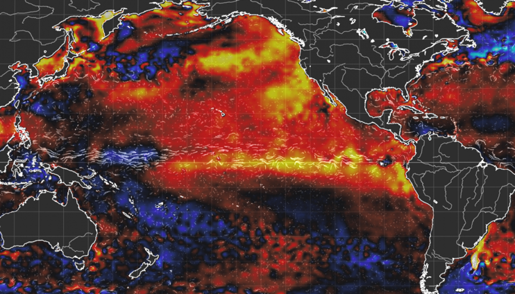
At the moment, this year’s El Niño is stronger than it was at this time of year in 1997. Areas in red and white represent the warmest sea-surface temperatures above the average. (Source: NASA Jet Propulsion Laboratory climatologist Bill Patzert)

Related Posts

End-of-life boat collection →
Good news for Atlantic hurricane season →

Can’t make this stuff up →