Expect an Extremely Dangerous Hurricane
Published on September 10th, 2018
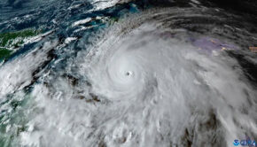
Every worst fear is coming to fruition as USA prepares for Florence, the sixth storm of the 2018 Atlantic season.
On August 28, the National Hurricane Center (NHC) first mentioned the possibility of tropical cyclone formation from a tropical wave expected to exit western Africa. Two days later, the tropical wave moved off the coast of Senegal, named Florence, and is now coming in for a direct hit on the southeast USA.
No storm has ever followed Florence’s track. A high pressure system prevented the usual northerly bend, and while this spared Bermuda, the storm’s westerly approach will allow the counter-clockwise spin of the storm to assert its full fury on the coast.
The NHC Public Advisories, while detailed, are generally void of descriptive prose that a layperson needs. However, this one got our attention:

500 PM AST Mon Sep 10 2018
LOCATION…25.4N 61.1W
ABOUT 525 MI SSE OF BERMUDA
ABOUT 1170 MI ESE OF CAPE FEAR NORTH CAROLINA
MAXIMUM SUSTAINED WINDS…140 MPH…220 KM/H
PRESENT MOVEMENT…WNW OR 285 DEGREES AT 13 MPH
WATCHES AND WARNINGS
There are no coastal watches or warnings in effect.
Interests in the southeastern and mid-Atlantic states should monitor the progress of Florence. Storm Surge and Hurricane watches could be issued for portions of these areas by Tuesday morning, September 11.
DISCUSSION AND OUTLOOK
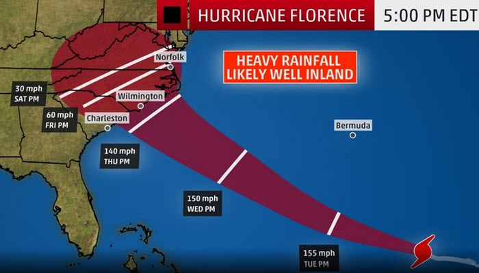
At 500 PM AST (2100 UTC), the eye of Hurricane Florence was located near latitude 25.4 North, longitude 61.1 West. Florence is moving toward the west-northwest near 13 mph (20 km/h). This general motion with an increase in forward speed is expected during the next couple of days.
A turn toward the northwest is forecast to occur late Wednesday night. On the forecast track, the center of Florence will move over the southwestern Atlantic Ocean between Bermuda and the Bahamas Tuesday and Wednesday, and approach the coast of South Carolina or North Carolina on Thursday.
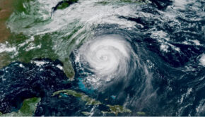
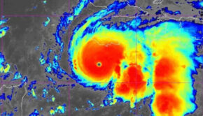
Data from a NOAA Hurricane Hunter aircraft indicate that maximum sustained winds have increased near 140 mph (220 km/h) with higher gusts. Florence is a category 4 hurricane on the Saffir-Simpson Hurricane Wind Scale. Further strengthening is anticipated, and Florence is expected to be an extremely dangerous major hurricane through Thursday.
Hurricane-force winds extend outward up to 40 miles (65 km) from the center and tropical-storm-force winds extend outward up to 150 miles (240 km).
The estimated minimum central pressure from NOAA Hurricane Hunter aircraft data is 939 mb (27.73 inches).
HAZARDS AFFECTING LAND
Swells generated by Florence are affecting Bermuda and portions of the U.S. East Coast. These swells are likely to cause life-threatening surf and rip current conditions.

Related Posts
Good news for Atlantic hurricane season →

Three places overdue for hurricane →
Limitations of the Saffir-Simpson scale →