
Self-driving boat maps underwater terrain
Published on June 28th, 2023
You may have seen cars with sophisticated cameras on the roof, driving the roads to update navigation mapping. Now that is happening on the water with self-driving boats to better understand the sea floor.
Researchers at The University of Texas at El Paso have constructed a fully autonomous boat that can carry out bathymetric surveys — surveys of the depth and terrain of bodies of water like oceans, rivers and lakes. The team hopes the robotic boat can help simplify the survey process, which usually takes a crew of individuals to complete, as well as assist with reconnaissance missions.
“If you want to work in water-related studies, you need to know the shape and landscape of bodies of water,” said Laura Alvarez, Ph.D., lead author of the study, and an assistant professor in UTEP’s Department of Earth, Environmental and Resource Sciences.
Alvarez specializes in unmanned systems for earth science and started developing the boat several years ago but needed help tweaking and perfecting the system. That’s when she recruited science and electrical engineering master’s student Fernando Sotelo ‘22.

“The first time we tested the boat was at the swimming pool at UTEP — just to make sure it could float,” laughed Sotelo, study co-author and now UTEP alumnus.
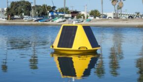
Over the course of a year, Sotelo refined the aluminum watercraft, a 3-foot-by-3-foot circular craft that rests on a thick black inner tube, testing it in various environments.
His goals included extending the boat’s hours of operation and reliability; and making it fully autonomous and responsive to potential environmental issues like wind speed and temperature flux. Now, a fail-safe can detect when batteries are low or wind gusts are too high and triggers a return-to-base function.
The rudderless watercraft operates with four thrusters, allowing it to travel up to 5 feet per second and easily rotate 360-degrees. A solar panel and lithium battery allow the boat to last up to four hours at sea — covering an area up to 472,400 square feet.
All the while a multi-beam echo-sounder — a sonar system — emits sound waves from the bottom of the boat. Water depth can be calculated by the time it takes for the sound wave to water to hit the seafloor and return to the sonar system. The sound itself that returns to the device can help detect the type of material on the seafloor.
Alvarez has put the instructions to replicate the boat online. “The reason we wrote the paper was so that anyone can reproduce it by themselves,” she said. “It serves as an effective guideline to get them started.”
The boat and its capabilities are described in the May issue of the journal Sensors.

Related Posts
Studying unsteady maneuvers →
In pursuit of environmental data →

Sailing (on purpose) into a hurricane →

 We’ll keep your information safe.