Strongest Hurricane Ever Recorded Approaching Mexico
Published on October 23rd, 2015
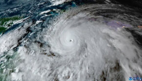
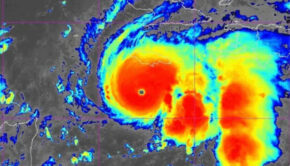
(October 23, 2015) – With 200-mph sustained winds and even more powerful gusts, CNN reports that Hurricane Patricia is the strongest hurricane ever recorded by the U.S. National Hurricane Center and it’s barreling toward Mexico’s Pacific coast Friday.
The Miami-based meteorological center, in its 8 a.m. advisory, warned of a “potentially catastrophic landfall in southwestern Mexico” later Friday. While its strength could fluctuate, “Patricia is expected to remain an extremely dangerous Category 5 hurricane through landfall.”
Patricia has potential to cause massive death and destruction for a large swath of the Mexican Pacific coast, including the tourist hot spots of Puerto Vallarta and Acapulco.
Citing observations by hurricane hunters, Patricia is “the strongest hurricane on record in the National Hurricane Center’s area of responsibility (AOR) which includes the Atlantic and the eastern North Pacific basins,” according to a Friday morning forecast discussion:

NWS NATIONAL HURRICANE CENTER MIAMI FL
1000 AM CDT FRI OCT 23 2015
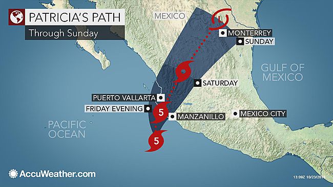
There has been little change in the satellite appearance of Patricia since the earlier Hurricane Hunter aircraft left the hurricane. Based on this, the initial intensity remains 175 kt. Some fluctuations in strength are possible before landfall, but it is expected that Patricia will make landfall as a Category 5 hurricane in southwestern Mexico in less than 12 hours. After landfall, a combination of the mountainous terrain of Mexico and increasing shear should cause the cyclone to rapidly weaken, with the system likely to dissipate completely after 36 hours.
The hurricane has turned northward since the previous advisory and the initial motion is now 005/9. Patricia is about to recurve into the westerlies between a mid-level anticyclone to its east and a deep-layer trough over northwestern Mexico and the southwestern U. S. These features should steer the cyclone generally north-northeastward across western and northern Mexico until dissipation occurs. The new forecast track is an update of the previous track.
The global models continue to depict the development of a cyclone near the Texas coast over the weekend. This system should be non-tropical in nature. However, this cyclone is expected to draw significant amounts of moisture from Patricia’s remnants, and could result in locally heavy rainfall over portions of the northwestern Gulf of Mexico coastal area within the next few days. Refer to statements from local National Weather Service forecast offices for details.
KEY MESSAGES:
1. Confidence is high that Patricia will make landfall in the hurricane warning area along the coast of Mexico as an extremely dangerous category 5 hurricane this afternoon or evening. Preparations to protect life and property in the hurricane warning area should have been completed, or rushed to completion, as tropical storm conditions are spreading across the area. Residents in low-lying areas near the coast in the hurricane warning area should evacuate immediately, since the storm surge could be catastrophic near and to the east of where the center makes landfall.
2. In addition to the coastal impacts, very heavy rainfall is likely to cause life-threatening flash floods and mud slides in the Mexican states of Jalisco, Colima, Michoacan and Guerrero continuing into Saturday.
3. At this time, the Category 5 winds are occurring over a very small area near the center – about 15 miles across. A NOAA Hurricane Hunter aircraft is scheduled to investigate Patricia before landfall to see what changes in intensity and structure have occurred.
FORECAST POSITIONS AND MAX WINDS
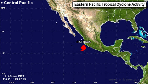
INIT 23/1500Z 17.6N 105.5W 175 KT 200 MPH
12H 24/0000Z 19.8N 105.1W 130 KT 150 MPH…INLAND
24H 24/1200Z 22.9N 103.6W 60 KT 70 MPH…INLAND
36H 25/0000Z 25.7N 101.6W 20 KT 25 MPH…POST-TROP/REMNT LOW
48H 25/1200Z…DISSIPATED

Related Posts
Good news for Atlantic hurricane season →

Three places overdue for hurricane →
Limitations of the Saffir-Simpson scale →