Dorian gathering strength nearing US
Published on August 28th, 2019
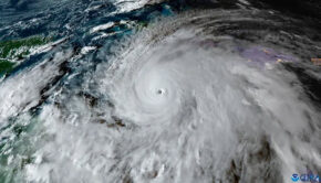
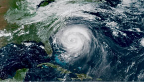
(August 28, 2019) – Tropical Storm Dorian officially became Hurricane Dorian today, its sustained winds topping 75 mph as it bore down on Puerto Rico and St. Thomas in the Virgin Islands. Forecasters are now warning that the storm will strengthen into a dangerous Category 3 hurricane as it nears the U.S. mainland.
Puerto Rico, Vieques, and the Virgin Islands are under alert, with hurricane conditions expected as the storm passes through that area. Dorian is currently crossing over St. Thomas, the National Hurricane Center (NHC) said today in its 2 p.m. ET update. The storm is moving northwest at around 13 mph.
An elevated weather station on Buck Island just south of St. Thomas reported a sustained wind of 82 mph and a gust of 111 mph.
While Dorian could lose some intensity as it passes over the land mass, the storm steadily gained power and became better organized today. Within four days, its winds could top 115 mph, the National Hurricane Center says.

All indications are that by this Labor Day weekend, a powerful hurricane will be near the Florida or southeastern coast of the United States.
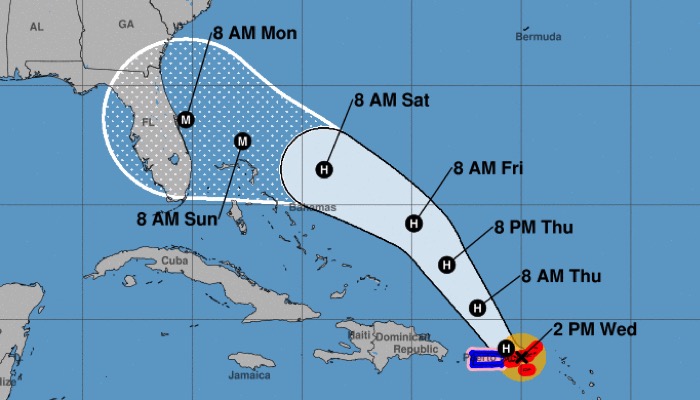
Dorian is expected to become a major hurricane (Category 3 and above) as it moves north of the Bahamas. The NHC’s current predictions show Dorian’s center hitting Florida’s coast early on September 2. But the Florida coast could see tropical-storm-force winds arrive as early as Saturday night, August 31.
The center currently predicts the storm will make landfall near an area that’s roughly level with Orlando. But that potential location could shift drastically as the storm develops.
While the NHC initially predicted the storm would weaken somewhat into a Category 2 — with winds of 100 mph — as it drew close to Florida’s coast, the center quickly issued a correction to its 11 a.m. update, clarifying that the storm will likely arrive as a major hurricane.
Forecasters warn of the potential for life-threatening flash floods in the storm’s path. Southern and eastern portions of Puerto Rico and the Virgin Islands could see 4-6 inches of rainfall, with 10 inches possible in isolated areas. When the storm reaches Florida, it’s expected to drop 4-8 inches of rain, with 10 inches in some spots.
NHC Director Ken Graham cautioned that for Florida, even though Dorian is estimated to make landfall as of 8 a.m. ET Monday (September 2), “the impacts could come a lot earlier than that,” saying intense rain, tropical-storm winds and a storm surge could begin to affect the coastline far from the storm’s center.
Acknowledging that considerable uncertainty remains over the path Dorian will take, Graham also said anyone on the southeastern U.S. coast from Florida up through Georgia and South Carolina should watch for potential hazards.
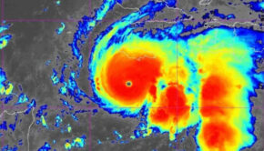
“Dorian remains a compact and asymmetric tropical storm,” the NHC says, citing data collected from Air Force Hurricane Hunters and other sources. But that could change — the center says some projection models show Dorian “increasing in size by the time it nears the southeast U.S.”
While Dorian’s wind speeds and size remained fairly stable earlier this week, the hurricane center is now projecting tropical storm-force winds outward up to 80 miles from the center — up from 45 miles earlier this week. Its hurricane-force winds extend up to 20 miles from the storm’s center.
As it announced an increased threat of hurricane conditions on Florida’s east coast, the hurricane center noted early today that forecasts are “on the lower end of the guidance envelope” — meaning it could raise more dire warnings as the storm continues to develop.
By 9:30 a.m. ET today, Dorian’s outer bands were beginning to move over eastern Puerto Rico, according to the National Weather Service office in San Juan.
To prepare for rough conditions at sea, the Coast Guard captain in San Juan set “Port Condition ZULU” today for all ports in the U.S. Virgin Islands and Puerto Rico, shutting down all commercial traffic until the storm has passed and the facilities have been assessed.
The fifth named storm of the 2019 Atlantic season formed late yesterday, as Tropical Storm Erin’s winds reached 40 mph. The storm, which was several hundred miles southeast of Cape Hatteras, N.C., was downgraded to a tropical depression today. Erin is expected to remain on a north-northeastern track, likely arriving at Canada’s coast late this week.
Details: https://www.nhc.noaa.gov/cyclones/
Source: NPR and NHC/NOAA

Related Posts
Good news for Atlantic hurricane season →

Three places overdue for hurricane →
Limitations of the Saffir-Simpson scale →