
Special Tropical Weather Outlook
Published on May 7th, 2015
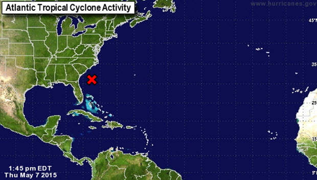
As of 1345 EDT on May 7, 2015, data from an Air Force Reserve Hurricane Hunter aircraft indicate that the nearly stationary area of low pressure located about 210 miles south-southeast of the South Carolina-North Carolina border is now producing 40-45 mph winds mainly to the north and west of the center.
Environmental conditions are favorable for some additional development, and any increase in the organization of the associated thunderstorm activity would result in the formation of a subtropical cyclone. The low is expected to drift to the north or north- northwest over the next couple of days, and interests along the southeastern coast of the United States should continue to monitor the progress of this system.
Regardless of development, heavy rain is expected over portions of the coastal southeastern United States for the next few days.
* Formation chance through 48 hours…high…80 percent
* Formation chance through 5 days…high…80 percent

More updates here: http://www.nhc.noaa.gov/cyclones/?atlc

Related Posts
Is your name on the 2024 storm list? →

2023 Atlantic Hurricane Season wraps up →

Memories of Ian return as Nicole looms →
 We’ll keep your information safe.